

Hochschwab csoport 3
A cycling route starting in Eisenerz, Styria, Austria.
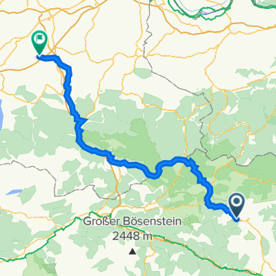
Overview
About this route
Präbichl
Reichensteinhütte
Eisenerzer Reichenstein (2165 m)
Reichensteinhütte
Rössel (1855 m)
Präbichl
- -:--
- Duration
- 11 km
- Distance
- 1,003 m
- Ascent
- 1,003 m
- Descent
- ---
- Avg. speed
- ---
- Max. altitude

Continue with Bikemap
Use, edit, or download this cycling route
You would like to ride Hochschwab csoport 3 or customize it for your own trip? Here is what you can do with this Bikemap route:
Free features
- Save this route as favorite or in collections
- Copy & plan your own version of this route
- Sync your route with Garmin or Wahoo
Premium features
Free trial for 3 days, or one-time payment. More about Bikemap Premium.
- Navigate this route on iOS & Android
- Export a GPX / KML file of this route
- Create your custom printout (try it for free)
- Download this route for offline navigation
Discover more Premium features.
Get Bikemap PremiumFrom our community
Other popular routes starting in Eisenerz
 RT2014_3
- Distance
- 8.7 km
- Ascent
- 596 m
- Descent
- 78 m
- Location
- Eisenerz, Styria, Austria
 Hochschwab csoport 3
- Distance
- 11 km
- Ascent
- 1,003 m
- Descent
- 1,003 m
- Location
- Eisenerz, Styria, Austria
 Hochschwab csoport 5
- Distance
- 23.2 km
- Ascent
- 274 m
- Descent
- 792 m
- Location
- Eisenerz, Styria, Austria
 Hieflauer Straße 43, Eisenerz nach Hauptstraße 12, Eberstalzell
- Distance
- 129.4 km
- Ascent
- 1,966 m
- Descent
- 2,257 m
- Location
- Eisenerz, Styria, Austria
 Plankogel Eisenerz
- Distance
- 9.1 km
- Ascent
- 506 m
- Descent
- 617 m
- Location
- Eisenerz, Styria, Austria
 Hochschwab csoport 4
- Distance
- 16.8 km
- Ascent
- 1,714 m
- Descent
- 1,443 m
- Location
- Eisenerz, Styria, Austria
 Eisenerz dream
- Distance
- 24.8 km
- Ascent
- 1,045 m
- Descent
- 1,045 m
- Location
- Eisenerz, Styria, Austria
 RT2014_04
- Distance
- 50.2 km
- Ascent
- 69 m
- Descent
- 836 m
- Location
- Eisenerz, Styria, Austria
Open it in the app