

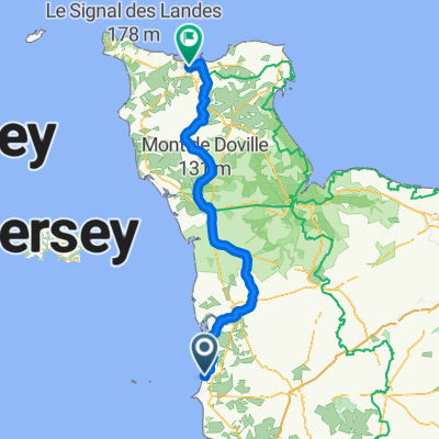
cerences_saint lo
A cycling route starting in Bréhal, Normandy, France.
Overview
About this route
- -:--
- Duration
- 61.8 km
- Distance
- 377 m
- Ascent
- 401 m
- Descent
- ---
- Avg. speed
- ---
- Max. altitude

Continue with Bikemap
Use, edit, or download this cycling route
You would like to ride cerences_saint lo or customize it for your own trip? Here is what you can do with this Bikemap route:
Free features
- Save this route as favorite or in collections
- Copy & plan your own version of this route
- Sync your route with Garmin or Wahoo
Premium features
Free trial for 3 days, or one-time payment. More about Bikemap Premium.
- Navigate this route on iOS & Android
- Export a GPX / KML file of this route
- Create your custom printout (try it for free)
- Download this route for offline navigation
Discover more Premium features.
Get Bikemap PremiumFrom our community
Other popular routes starting in Bréhal
 Normandie_north
- Distance
- 50.6 km
- Ascent
- 395 m
- Descent
- 285 m
- Location
- Bréhal, Normandy, France
 03-stmlchrb
- Distance
- 52.1 km
- Ascent
- 106 m
- Descent
- 103 m
- Location
- Bréhal, Normandy, France
 De 5 Impasse des Goelettes, Bréhal à 5 Impasse des Goelettes, Bréhal
- Distance
- 2,681.8 km
- Ascent
- 7,302 m
- Descent
- 7,302 m
- Location
- Bréhal, Normandy, France
 Rue des Gabions, Bréhal nach Rue des Gabions, Bréhal
- Distance
- 37.8 km
- Ascent
- 331 m
- Descent
- 329 m
- Location
- Bréhal, Normandy, France
 D 597, Bréhal à 3–7 Chemin de la Fontenelle, Bréhal
- Distance
- 0.5 km
- Ascent
- 23 m
- Descent
- 0 m
- Location
- Bréhal, Normandy, France
 114 Saint-Martin-le-Vieux, Bréhal à 4 Avenue Louis Périer, Agon-Coutainville
- Distance
- 22.3 km
- Ascent
- 122 m
- Descent
- 102 m
- Location
- Bréhal, Normandy, France
 F07a hoogwateralternatief
- Distance
- 2.7 km
- Ascent
- 4 m
- Descent
- 0 m
- Location
- Bréhal, Normandy, France
 Bréhal - Cherbourg-Octeville
- Distance
- 127.6 km
- Ascent
- 939 m
- Descent
- 940 m
- Location
- Bréhal, Normandy, France
Open it in the app