

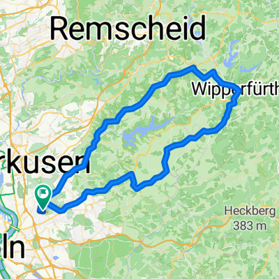
Dünnthalsperren-Tour
A cycling route starting in Mülheim, North Rhine-Westphalia, Germany.
Overview
About this route
- -:--
- Duration
- 52.3 km
- Distance
- 524 m
- Ascent
- 510 m
- Descent
- ---
- Avg. speed
- ---
- Max. altitude

Route quality
Waytypes & surfaces along the route
Waytypes
Busy road
36.6 km
(70 %)
Quiet road
6.3 km
(12 %)
Surfaces
Paved
46.3 km
(89 %)
Unpaved
1.5 km
(3 %)
Asphalt
44 km
(84 %)
Paving stones
2.3 km
(4 %)
Continue with Bikemap
Use, edit, or download this cycling route
You would like to ride Dünnthalsperren-Tour or customize it for your own trip? Here is what you can do with this Bikemap route:
Free features
- Save this route as favorite or in collections
- Copy & plan your own version of this route
- Sync your route with Garmin or Wahoo
Premium features
Free trial for 3 days, or one-time payment. More about Bikemap Premium.
- Navigate this route on iOS & Android
- Export a GPX / KML file of this route
- Create your custom printout (try it for free)
- Download this route for offline navigation
Discover more Premium features.
Get Bikemap PremiumFrom our community
Other popular routes starting in Mülheim
 Abendrunde
- Distance
- 40.9 km
- Ascent
- 518 m
- Descent
- 521 m
- Location
- Mülheim, North Rhine-Westphalia, Germany
 warmrollen im bergischen land
- Distance
- 141.9 km
- Ascent
- 1,037 m
- Descent
- 1,037 m
- Location
- Mülheim, North Rhine-Westphalia, Germany
 Dünnthalsperren-Tour
- Distance
- 52.3 km
- Ascent
- 524 m
- Descent
- 510 m
- Location
- Mülheim, North Rhine-Westphalia, Germany
 Balkanroute über Schlebusch Gravel 47
- Distance
- 47 km
- Ascent
- 284 m
- Descent
- 285 m
- Location
- Mülheim, North Rhine-Westphalia, Germany
 Balkantrasse bis Bergisch Born nach Lennep.
- Distance
- 73.5 km
- Ascent
- 424 m
- Descent
- 402 m
- Location
- Mülheim, North Rhine-Westphalia, Germany
 RTF Köln (Ford) 2007 2Pkt
- Distance
- 74.9 km
- Ascent
- 726 m
- Descent
- 703 m
- Location
- Mülheim, North Rhine-Westphalia, Germany
 Neue Route durch den Königsforst
- Distance
- 69.1 km
- Ascent
- 244 m
- Descent
- 223 m
- Location
- Mülheim, North Rhine-Westphalia, Germany
 E- Bike Bergisch Gladgach auch für das Trekkingbike geeignet.
- Distance
- 44.7 km
- Ascent
- 439 m
- Descent
- 437 m
- Location
- Mülheim, North Rhine-Westphalia, Germany
Open it in the app