

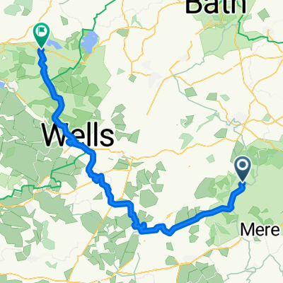
Figure_of_Hate
A cycling route starting in Kilmington, England, United Kingdom.
Overview
About this route
- -:--
- Duration
- 33.3 km
- Distance
- 419 m
- Ascent
- 418 m
- Descent
- ---
- Avg. speed
- ---
- Max. altitude
Route quality
Waytypes & surfaces along the route
Waytypes
Road
21 km
(63 %)
Quiet road
9.3 km
(28 %)
Surfaces
Paved
2.7 km
(8 %)
Asphalt
2.7 km
(8 %)
Undefined
30.6 km
(92 %)
Continue with Bikemap
Use, edit, or download this cycling route
You would like to ride Figure_of_Hate or customize it for your own trip? Here is what you can do with this Bikemap route:
Free features
- Save this route as favorite or in collections
- Copy & plan your own version of this route
- Sync your route with Garmin or Wahoo
Premium features
Free trial for 3 days, or one-time payment. More about Bikemap Premium.
- Navigate this route on iOS & Android
- Export a GPX / KML file of this route
- Create your custom printout (try it for free)
- Download this route for offline navigation
Discover more Premium features.
Get Bikemap PremiumFrom our community
Other popular routes starting in Kilmington
 King Alfreds Tower to Frome
- Distance
- 23.5 km
- Ascent
- 284 m
- Descent
- 434 m
- Location
- Kilmington, England, United Kingdom
 stourton to Hengistbury head
- Distance
- 69.7 km
- Ascent
- 498 m
- Descent
- 676 m
- Location
- Kilmington, England, United Kingdom
 Kilmington - Blagdon
- Distance
- 64.4 km
- Ascent
- 781 m
- Descent
- 842 m
- Location
- Kilmington, England, United Kingdom
 Stourhead to Bournemouth
- Distance
- 72 km
- Ascent
- 473 m
- Descent
- 668 m
- Location
- Kilmington, England, United Kingdom
 Tower Road, Bruton to Tower Road, Bruton
- Distance
- 18.5 km
- Ascent
- 403 m
- Descent
- 398 m
- Location
- Kilmington, England, United Kingdom
 Tower Road, Kilmington, Warminster to A371, Ditcheat, Evercreech, Shepton Mallet
- Distance
- 17.9 km
- Ascent
- 1,028 m
- Descent
- 1,193 m
- Location
- Kilmington, England, United Kingdom
 Kilmington Common, Kilmington, Warminster to A361, Cranmore, East Cranmore, Shepton Mallet
- Distance
- 17.3 km
- Ascent
- 297 m
- Descent
- 346 m
- Location
- Kilmington, England, United Kingdom
 Figure_of_Hate
- Distance
- 33.3 km
- Ascent
- 419 m
- Descent
- 418 m
- Location
- Kilmington, England, United Kingdom
Open it in the app