

A la Torca del Lobo
A cycling route starting in Cuenca, Castille-La Mancha, Spain.
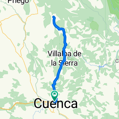
Overview
About this route
- -:--
- Duration
- 47.5 km
- Distance
- 733 m
- Ascent
- 734 m
- Descent
- ---
- Avg. speed
- ---
- Max. altitude
Route highlights
Points of interest along the route
Point of interest after 13.7 km
Primera Senda corta de bajada.
Point of interest after 17.7 km
Nos desviamos a otra senda que está muy poco marcada y bajamos realmente por el cauce del barranco. Hay tramos de bajar a pie.
Point of interest after 18.6 km
Fuente del Royo

Photo after 25.2 km
Torca del Lobo

Photo after 25.9 km
Torca la Rubia
Point of interest after 32.6 km
La senda que empezamos ha hacer de subida se divide, nosotros subimos por un lado y bajamos por el otro.
Point of interest after 35.7 km
Bajamos por una senda por la cual tendremos que desmontarnos en algún momento por las fuertes pendientes hacia arriba.

Photo after 36.8 km
Barranco de el Portillo.
Continue with Bikemap
Use, edit, or download this cycling route
You would like to ride A la Torca del Lobo or customize it for your own trip? Here is what you can do with this Bikemap route:
Free features
- Save this route as favorite or in collections
- Copy & plan your own version of this route
- Sync your route with Garmin or Wahoo
Premium features
Free trial for 3 days, or one-time payment. More about Bikemap Premium.
- Navigate this route on iOS & Android
- Export a GPX / KML file of this route
- Create your custom printout (try it for free)
- Download this route for offline navigation
Discover more Premium features.
Get Bikemap PremiumFrom our community
Other popular routes starting in Cuenca
 Cabeza Mosilla
- Distance
- 42.5 km
- Ascent
- 884 m
- Descent
- 884 m
- Location
- Cuenca, Castille-La Mancha, Spain
 Piedra del Yunque
- Distance
- 57.9 km
- Ascent
- 676 m
- Descent
- 668 m
- Location
- Cuenca, Castille-La Mancha, Spain
 Cuenca - Cerro Sorroco - Palomera - Cuenca
- Distance
- 27.1 km
- Ascent
- 466 m
- Descent
- 465 m
- Location
- Cuenca, Castille-La Mancha, Spain
 Palomera, Buenache de la Sierra, Valdecabras.
- Distance
- 52.8 km
- Ascent
- 612 m
- Descent
- 613 m
- Location
- Cuenca, Castille-La Mancha, Spain
 Cuenca - Cuevas Velasco - Valdecolmenas - Villarejo Peñuela - Cuenca
- Distance
- 80.7 km
- Ascent
- 879 m
- Descent
- 790 m
- Location
- Cuenca, Castille-La Mancha, Spain
 Cuenca - Villalba - Fresneda - Villalba - Cuenca
- Distance
- 85.1 km
- Ascent
- 813 m
- Descent
- 790 m
- Location
- Cuenca, Castille-La Mancha, Spain
 Vallejo del Pumar
- Distance
- 45.3 km
- Ascent
- 655 m
- Descent
- 654 m
- Location
- Cuenca, Castille-La Mancha, Spain
 Primer tramo Maraton "Sendas de Cuenca"
- Distance
- 37.7 km
- Ascent
- 668 m
- Descent
- 670 m
- Location
- Cuenca, Castille-La Mancha, Spain
Open it in the app