

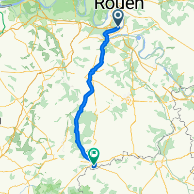
Oissel-Giverny-Oissel
A cycling route starting in Oissel, Normandy, France.
Overview
About this route
- -:--
- Duration
- 138 km
- Distance
- 315 m
- Ascent
- 315 m
- Descent
- ---
- Avg. speed
- ---
- Max. altitude

Route quality
Waytypes & surfaces along the route
Waytypes
Busy road
57.1 km
(41 %)
Road
48.2 km
(35 %)
Surfaces
Paved
74.6 km
(54 %)
Unpaved
1 km
(<1 %)
Asphalt
67.5 km
(49 %)
Paved (undefined)
6.2 km
(4 %)
Continue with Bikemap
Use, edit, or download this cycling route
You would like to ride Oissel-Giverny-Oissel or customize it for your own trip? Here is what you can do with this Bikemap route:
Free features
- Save this route as favorite or in collections
- Copy & plan your own version of this route
- Split it into stages to create a multi-day tour
- Sync your route with Garmin or Wahoo
Premium features
Free trial for 3 days, or one-time payment. More about Bikemap Premium.
- Navigate this route on iOS & Android
- Export a GPX / KML file of this route
- Create your custom printout (try it for free)
- Download this route for offline navigation
Discover more Premium features.
Get Bikemap PremiumFrom our community
Other popular routes starting in Oissel
 Terres du Port d'Oissel, Tourville-la-Rivière à 4–8 Voie du Mesnil, Tourville-la-Rivière
- Distance
- 3.5 km
- Ascent
- 134 m
- Descent
- 150 m
- Location
- Oissel, Normandy, France
 maison à maison, passage st aubin, freneuse et tlr
- Distance
- 22.9 km
- Ascent
- 162 m
- Descent
- 162 m
- Location
- Oissel, Normandy, France
 Oissel-Giverny-Oissel
- Distance
- 138 km
- Ascent
- 315 m
- Descent
- 315 m
- Location
- Oissel, Normandy, France
 Oissel - Verneuil-sur-Avre
- Distance
- 89.1 km
- Ascent
- 425 m
- Descent
- 270 m
- Location
- Oissel, Normandy, France
 Oissel-SER en évitant le rp aux vaches
- Distance
- 10.9 km
- Ascent
- 21 m
- Descent
- 17 m
- Location
- Oissel, Normandy, France
 maison point de rencontre, boucles les essarts
- Distance
- 33.7 km
- Ascent
- 466 m
- Descent
- 462 m
- Location
- Oissel, Normandy, France
 De 1–3 Sente Crémerelle, Oissel à 51 Rue de Bayeux, Port-en-Bessin-Huppain
- Distance
- 173.1 km
- Ascent
- 993 m
- Descent
- 1,000 m
- Location
- Oissel, Normandy, France
 maison à maison, détour les essarts
- Distance
- 25.1 km
- Ascent
- 305 m
- Descent
- 305 m
- Location
- Oissel, Normandy, France
Open it in the app