

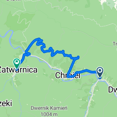
Otryt
A cycling route starting in Lutowiska, Subcarpathian Voivodeship, Poland.
Overview
About this route
- -:--
- Duration
- 39.4 km
- Distance
- 527 m
- Ascent
- 527 m
- Descent
- ---
- Avg. speed
- ---
- Max. altitude

Route quality
Waytypes & surfaces along the route
Waytypes
Track
22 km
(56 %)
Road
11 km
(28 %)
Surfaces
Paved
22 km
(56 %)
Unpaved
10.2 km
(26 %)
Paved (undefined)
11.8 km
(30 %)
Asphalt
10.2 km
(26 %)
Continue with Bikemap
Use, edit, or download this cycling route
You would like to ride Otryt or customize it for your own trip? Here is what you can do with this Bikemap route:
Free features
- Save this route as favorite or in collections
- Copy & plan your own version of this route
- Sync your route with Garmin or Wahoo
Premium features
Free trial for 3 days, or one-time payment. More about Bikemap Premium.
- Navigate this route on iOS & Android
- Export a GPX / KML file of this route
- Create your custom printout (try it for free)
- Download this route for offline navigation
Discover more Premium features.
Get Bikemap PremiumFrom our community
Other popular routes starting in Lutowiska
 Dwernik, Lutowiska do Zatwarnica, Lutowiska
- Distance
- 14.3 km
- Ascent
- 311 m
- Descent
- 306 m
- Location
- Lutowiska, Subcarpathian Voivodeship, Poland
 Zatwarnica
- Distance
- 40.4 km
- Ascent
- 501 m
- Descent
- 501 m
- Location
- Lutowiska, Subcarpathian Voivodeship, Poland
 2013-08-15 Bieszczady. Rower. Wzdłuż Pasma Otrytu po obu stronach Sanu.
- Distance
- 45.3 km
- Ascent
- 632 m
- Descent
- 633 m
- Location
- Lutowiska, Subcarpathian Voivodeship, Poland
 Bieszczady - wodospad
- Distance
- 11.3 km
- Ascent
- 130 m
- Descent
- 127 m
- Location
- Lutowiska, Subcarpathian Voivodeship, Poland
 Cyklotour 2015 - 1. deň
- Distance
- 61.3 km
- Ascent
- 647 m
- Descent
- 644 m
- Location
- Lutowiska, Subcarpathian Voivodeship, Poland
 Muczne - Sokoliki - Bacówka pod Małą Rawką
- Distance
- 57.5 km
- Ascent
- 1,253 m
- Descent
- 1,037 m
- Location
- Lutowiska, Subcarpathian Voivodeship, Poland
 Bieszczady-6
- Distance
- 36.1 km
- Ascent
- 716 m
- Descent
- 577 m
- Location
- Lutowiska, Subcarpathian Voivodeship, Poland
 Zatwarnica - wzdłuż Sanu - powrót
- Distance
- 19.6 km
- Ascent
- 299 m
- Descent
- 298 m
- Location
- Lutowiska, Subcarpathian Voivodeship, Poland
Open it in the app