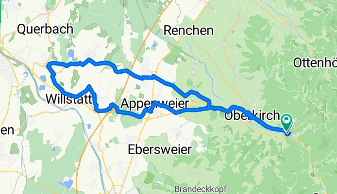
Lautenbach - Kork - Lautenbach
A cycling route starting in Lautenbach, Baden-Württemberg, Germany.
Overview
About this route
Schöneradtour durch die Ebene der Ortenau. sehr gut geignet im Frühjahr zumEinfahren
- -:--
- Duration
- 46.4 km
- Distance
- 81 m
- Ascent
- 84 m
- Descent
- ---
- Avg. speed
- ---
- Avg. speed
Route quality
Waytypes & surfaces along the route
Waytypes
Road
14.3 km
(31 %)
Quiet road
12.1 km
(26 %)
Surfaces
Paved
38.5 km
(83 %)
Unpaved
1.2 km
(2 %)
Asphalt
33.7 km
(73 %)
Paved (undefined)
2.2 km
(5 %)
Continue with Bikemap
Use, edit, or download this cycling route
You would like to ride Lautenbach - Kork - Lautenbach or customize it for your own trip? Here is what you can do with this Bikemap route:
Free features
- Save this route as favorite or in collections
- Copy & plan your own version of this route
- Sync your route with Garmin or Wahoo
Premium features
Free trial for 3 days, or one-time payment. More about Bikemap Premium.
- Navigate this route on iOS & Android
- Export a GPX / KML file of this route
- Create your custom printout (try it for free)
- Download this route for offline navigation
Discover more Premium features.
Get Bikemap PremiumFrom our community
Other popular routes starting in Lautenbach
- Kurze Fahr nach Allerheiligen
- Distance
- 33.2 km
- Ascent
- 1,219 m
- Descent
- 1,170 m
- Location
- Lautenbach, Baden-Württemberg, Germany
- Lautenbach - Erli
- Distance
- 32.2 km
- Ascent
- 880 m
- Descent
- 934 m
- Location
- Lautenbach, Baden-Württemberg, Germany
- Lautenbach - Kork - Lautenbach
- Distance
- 46.4 km
- Ascent
- 81 m
- Descent
- 84 m
- Location
- Lautenbach, Baden-Württemberg, Germany
- Lautenbach - Erli
- Distance
- 32.1 km
- Ascent
- 766 m
- Descent
- 829 m
- Location
- Lautenbach, Baden-Württemberg, Germany
- Lautenbach - St. Ursula - Stohlberg - Simmersbach - Haslach - Stadelhofen - Erli
- Distance
- 33 km
- Ascent
- 769 m
- Descent
- 825 m
- Location
- Lautenbach, Baden-Württemberg, Germany
- B28 8, Lautenbach nach L88, Oberkirch
- Distance
- 30.8 km
- Ascent
- 785 m
- Descent
- 776 m
- Location
- Lautenbach, Baden-Württemberg, Germany
- Bahnhofstraße 3, Lautenbach nach Dobelweg 22, Lautenbach
- Distance
- 31.2 km
- Ascent
- 1,395 m
- Descent
- 1,408 m
- Location
- Lautenbach, Baden-Württemberg, Germany
- Renchtal-Murgtalroute
- Distance
- 96.1 km
- Ascent
- 1,512 m
- Descent
- 1,512 m
- Location
- Lautenbach, Baden-Württemberg, Germany
Open it in the app