
Fife
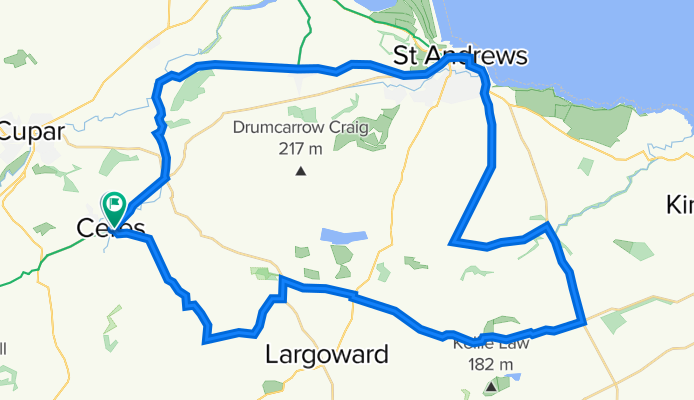
Ceres - St Andrews - Peat Inn circular
A cycling route starting in Ceres, Scotland, United Kingdom.
Overview
About this route
Start from the car park in Ceres (cafe adjacent), head to Pitscottie and tuke the downhill rin through Dura Den. From the bottom,back uphill to Strathkinnes and St Andrews. The return route avoids major roads apart from a short stretch along B1931. From New Gilston there is a fast descent into Ceres. All on good road.
- -:--
- Duration
- 46.7 km
- Distance
- 393 m
- Ascent
- 392 m
- Descent
- ---
- Avg. speed
- ---
- Max. altitude

Part of
4 stages
Route photos

Route quality
Waytypes & surfaces along the route
Waytypes
Road
18.6 km
(40 %)
Busy road
18.1 km
(39 %)
Surfaces
Paved
28.8 km
(62 %)
Unpaved
0.8 km
(2 %)
Asphalt
28.8 km
(62 %)
Unpaved (undefined)
0.8 km
(2 %)
Undefined
17 km
(37 %)
Continue with Bikemap
Use, edit, or download this cycling route
You would like to ride Ceres - St Andrews - Peat Inn circular or customize it for your own trip? Here is what you can do with this Bikemap route:
Free features
- Save this route as favorite or in collections
- Copy & plan your own version of this route
- Sync your route with Garmin or Wahoo
Premium features
Free trial for 3 days, or one-time payment. More about Bikemap Premium.
- Navigate this route on iOS & Android
- Export a GPX / KML file of this route
- Create your custom printout (try it for free)
- Download this route for offline navigation
Discover more Premium features.
Get Bikemap PremiumFrom our community
Other popular routes starting in Ceres
 B941, Cupar to 10 South Bridge, Cupar
- Distance
- 11.5 km
- Ascent
- 45 m
- Descent
- 217 m
- Location
- Ceres, Scotland, United Kingdom
 B941, Cupar to Abbey Park Avenue, St Andrews
- Distance
- 22.4 km
- Ascent
- 166 m
- Descent
- 336 m
- Location
- Ceres, Scotland, United Kingdom
 Ceres - Tay shore - Tentsmuir - Leuchars
- Distance
- 65.4 km
- Ascent
- 445 m
- Descent
- 446 m
- Location
- Ceres, Scotland, United Kingdom
 Old Hall, Cupar to Hillview, Ceres Road, Cupar
- Distance
- 8.4 km
- Ascent
- 73 m
- Descent
- 190 m
- Location
- Ceres, Scotland, United Kingdom
 Ceres - Falkland - Newburgh - Cupar
- Distance
- 57.4 km
- Ascent
- 650 m
- Descent
- 648 m
- Location
- Ceres, Scotland, United Kingdom
 Collierfield House, Cupar to East Neuk and Landward Ward, Fife
- Distance
- 18.8 km
- Ascent
- 78 m
- Descent
- 243 m
- Location
- Ceres, Scotland, United Kingdom
 peat inn hill route 1
- Distance
- 33.7 km
- Ascent
- 327 m
- Descent
- 303 m
- Location
- Ceres, Scotland, United Kingdom
 Ceres - Falkland - Auchtermuchty - Ladybank - Cupar
- Distance
- 52.8 km
- Ascent
- 355 m
- Descent
- 355 m
- Location
- Ceres, Scotland, United Kingdom
Open it in the app