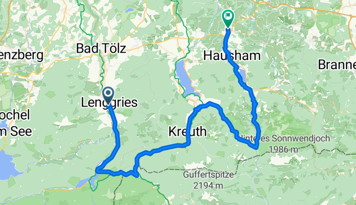
BOB-RR Lenggries-Miesbach
A cycling route starting in Lenggries, Bavaria, Germany.
Overview
About this route
Rennradtour mit Bob von München aus: Lenggries-Sylvenstein-Achenpass-Gmund am Tegernsee- Valepp-Spritzing - Schliersee-Miesbach
- -:--
- Duration
- 77.5 km
- Distance
- 806 m
- Ascent
- 801 m
- Descent
- ---
- Avg. speed
- ---
- Avg. speed
Route quality
Waytypes & surfaces along the route
Waytypes
Quiet road
23.1 km
(30 %)
Busy road
21.8 km
(28 %)
Surfaces
Paved
66.8 km
(86 %)
Unpaved
6.3 km
(8 %)
Asphalt
64.1 km
(83 %)
Gravel
6.1 km
(8 %)
Continue with Bikemap
Use, edit, or download this cycling route
You would like to ride BOB-RR Lenggries-Miesbach or customize it for your own trip? Here is what you can do with this Bikemap route:
Free features
- Save this route as favorite or in collections
- Copy & plan your own version of this route
- Sync your route with Garmin or Wahoo
Premium features
Free trial for 3 days, or one-time payment. More about Bikemap Premium.
- Navigate this route on iOS & Android
- Export a GPX / KML file of this route
- Create your custom printout (try it for free)
- Download this route for offline navigation
Discover more Premium features.
Get Bikemap PremiumFrom our community
Other popular routes starting in Lenggries
- RW 43km Fleck - Puppling
- Distance
- 43.2 km
- Ascent
- 225 m
- Descent
- 336 m
- Location
- Lenggries, Bavaria, Germany
- Tour 27 Wild Wild West
- Distance
- 46.9 km
- Ascent
- 1,191 m
- Descent
- 1,191 m
- Location
- Lenggries, Bavaria, Germany
- Lenggries - Lenggrieser Hütte
- Distance
- 12.1 km
- Ascent
- 762 m
- Descent
- 99 m
- Location
- Lenggries, Bavaria, Germany
- An der Benewand entlang
- Distance
- 41.4 km
- Ascent
- 900 m
- Descent
- 908 m
- Location
- Lenggries, Bavaria, Germany
- Lenggries - Seekarkreuz -Schwarze Tenn - Glashütte - Lenggries
- Distance
- 36 km
- Ascent
- 1,180 m
- Descent
- 1,180 m
- Location
- Lenggries, Bavaria, Germany
- Obergries - Aueralm - Obergries
- Distance
- 40.5 km
- Ascent
- 877 m
- Descent
- 875 m
- Location
- Lenggries, Bavaria, Germany
- leichter Downhill von der Lenggrieser Hütte zum Spitzingsee (Albert Link Hütte)
- Distance
- 36.5 km
- Ascent
- 588 m
- Descent
- 892 m
- Location
- Lenggries, Bavaria, Germany
- Von Lenggries auf den Brauneck
- Distance
- 14.2 km
- Ascent
- 816 m
- Descent
- 813 m
- Location
- Lenggries, Bavaria, Germany