

Etapa 077B (Goms - Aigle)
A cycling route starting in Fiesch, Valais, Switzerland.
Overview
About this route
Vuelta a Europa occidental. Etapa 77
Goms - Ernen - Grengiols - Bister - Bitsch - Naters - Brig - Lalden - Baltschieder - Rarona - Niedergesteln - Gampel Bratsch - Leuk - Sierre - Sion - Saillon - Fully - Vernayaz - Evionnaz - Saint Maurice - Massongex - Monthey - Collombey Muraz - Aigle
158.1 km
670 m desnivel acumulado positivo
- -:--
- Duration
- 158.1 km
- Distance
- 1,153 m
- Ascent
- 2,049 m
- Descent
- ---
- Avg. speed
- 1,323 m
- Max. altitude

Route quality
Waytypes & surfaces along the route
Waytypes
Quiet road
44.3 km
(28 %)
Track
39.5 km
(25 %)
Surfaces
Paved
120.2 km
(76 %)
Unpaved
14.2 km
(9 %)
Asphalt
118.6 km
(75 %)
Gravel
7.9 km
(5 %)
Route highlights
Points of interest along the route
Point of interest after 35.9 km
Stockalperschloss
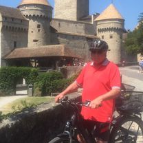
Point of interest after 156.3 km
Château d’Aigle
Continue with Bikemap
Use, edit, or download this cycling route
You would like to ride Etapa 077B (Goms - Aigle) or customize it for your own trip? Here is what you can do with this Bikemap route:
Free features
- Save this route as favorite or in collections
- Copy & plan your own version of this route
- Split it into stages to create a multi-day tour
- Sync your route with Garmin or Wahoo
Premium features
Free trial for 3 days, or one-time payment. More about Bikemap Premium.
- Navigate this route on iOS & Android
- Export a GPX / KML file of this route
- Create your custom printout (try it for free)
- Download this route for offline navigation
Discover more Premium features.
Get Bikemap PremiumFrom our community
Other popular routes starting in Fiesch
 Nufenen-Gotthard-Furka
- Distance
- 98.4 km
- Ascent
- 3,250 m
- Descent
- 2,708 m
- Location
- Fiesch, Valais, Switzerland
 coms
coms- Distance
- 35.1 km
- Ascent
- 435 m
- Descent
- 434 m
- Location
- Fiesch, Valais, Switzerland
 Alpenbrevet (Variante)
- Distance
- 209.7 km
- Ascent
- 4,645 m
- Descent
- 4,645 m
- Location
- Fiesch, Valais, Switzerland
 Glacier du Rhone (Furka-Susten-Grimsel) 156KM 4.2KD+
- Distance
- 155.8 km
- Ascent
- 3,843 m
- Descent
- 3,843 m
- Location
- Fiesch, Valais, Switzerland
 Gommer Höhenweg 41, Bellwald nach Gommer Höhenweg 40, Bellwald
- Distance
- 19.3 km
- Ascent
- 493 m
- Descent
- 527 m
- Location
- Fiesch, Valais, Switzerland
 Kurze Radrunde durch Bettmeralp
- Distance
- 5.2 km
- Ascent
- 118 m
- Descent
- 141 m
- Location
- Fiesch, Valais, Switzerland
 CH 512: Reckingen - Oberwald SBB
- Distance
- 11.3 km
- Ascent
- 62 m
- Descent
- 6 m
- Location
- Fiesch, Valais, Switzerland
 Ulrichen - Chiggiogna
- Distance
- 84.8 km
- Ascent
- 2,418 m
- Descent
- 3,061 m
- Location
- Fiesch, Valais, Switzerland
Open it in the app