Etapa 090B (Frontignan - Narbona)
A cycling route starting in Frontignan, Occitanie, France.
Overview
About this route
Vuelta a Europa occidental. Etapa 90
Frontignan - Sète - Agde - Portiragnes - Villeneuve lès Béziers - Béziers - Colombiers - Poilhes - Capestang - Argeliers - Sallèles-d'Aude - Cuxac d'Aude - Narbona -
125.7 km
210 m desnivel positivo acumulado
- -:--
- Duration
- 125.7 km
- Distance
- 404 m
- Ascent
- 400 m
- Descent
- ---
- Avg. speed
- 75 m
- Max. altitude
Route quality
Waytypes & surfaces along the route
Waytypes
Cycleway
46.5 km
(37 %)
Path
28.9 km
(23 %)
Surfaces
Paved
55.4 km
(44 %)
Unpaved
45.6 km
(36 %)
Asphalt
52.3 km
(42 %)
Gravel
24.8 km
(20 %)
Route highlights
Points of interest along the route
Point of interest after 10.5 km
Halles de Sète
Point of interest after 12 km
Phare Saint-Louis
Point of interest after 65.9 km
Cathédrale Saint-Nazaire
Point of interest after 66.2 km
Les Halles
Point of interest after 67.3 km
Pont Vieux
Point of interest after 68.6 km
Les 9 Écluses de Fonseranes
Point of interest after 87.1 km
Collégiale Saint-Étienne
Point of interest after 122.1 km
Palais-Musée des Archevêques, Palais Vieux
Point of interest after 122.1 km
Cathédrale Saint-Just et Saint-Pasteur
Point of interest after 122.1 km
Pont des Marchands
Point of interest after 122.3 km
Les Halles de Narbonne
Continue with Bikemap
Use, edit, or download this cycling route
You would like to ride Etapa 090B (Frontignan - Narbona) or customize it for your own trip? Here is what you can do with this Bikemap route:
Free features
- Save this route as favorite or in collections
- Copy & plan your own version of this route
- Split it into stages to create a multi-day tour
- Sync your route with Garmin or Wahoo
Premium features
Free trial for 3 days, or one-time payment. More about Bikemap Premium.
- Navigate this route on iOS & Android
- Export a GPX / KML file of this route
- Create your custom printout (try it for free)
- Download this route for offline navigation
Discover more Premium features.
Get Bikemap PremiumFrom our community
Other popular routes starting in Frontignan
- Pont du Rond-point des Étangs, Frontignan to Boulevard des Aresquiers, Vic-la-Gardiole
- Distance
- 10.7 km
- Ascent
- 22 m
- Descent
- 21 m
- Location
- Frontignan, Occitanie, France
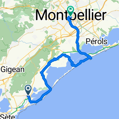
- Etappe alt 13 Frontignan - Gignac
- Distance
- 43.6 km
- Ascent
- 410 m
- Descent
- 361 m
- Location
- Frontignan, Occitanie, France
- tag4
- Distance
- 58.8 km
- Ascent
- 77 m
- Descent
- 21 m
- Location
- Frontignan, Occitanie, France
- 3. nap
- Distance
- 112.8 km
- Ascent
- 319 m
- Descent
- 317 m
- Location
- Frontignan, Occitanie, France
- Frontignan-Montpellier 6. Tag, Variation 1
- Distance
- 43.3 km
- Ascent
- 103 m
- Descent
- 48 m
- Location
- Frontignan, Occitanie, France
- Arresquiers Sète Frontignan
- Distance
- 33.8 km
- Ascent
- 72 m
- Descent
- 95 m
- Location
- Frontignan, Occitanie, France
- Etapa 090B (Frontignan - Narbona)
- Distance
- 125.7 km
- Ascent
- 404 m
- Descent
- 400 m
- Location
- Frontignan, Occitanie, France
- Frontignan
- Distance
- 33.8 km
- Ascent
- 255 m
- Descent
- 255 m
- Location
- Frontignan, Occitanie, France
Open it in the app