
CIRCUIT D ITALIE
A cycling route starting in Saint-Chaffrey, Provence-Alpes-Côte d'Azur Region, France.
Overview
About this route
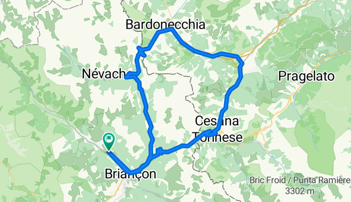
<p><strong>Distance 82 km </strong><strong>(ID required) Serre Chevalier - Col de l’Echelle - Bardonnechia, Oulx, Col de Montgenèvre Briançon - Serre Chevalier. AVERAGE TIME: 5 hours. ELEVATION: 1000 meters MAXIMUM SLOPE: 9%</strong></p>
Translated, show original (French)- -:--
- Duration
- 82.5 km
- Distance
- 1,326 m
- Ascent
- 1,325 m
- Descent
- ---
- Avg. speed
- ---
- Max. altitude

Route quality
Waytypes & surfaces along the route
Waytypes
Road
15.7 km
(19 %)
Quiet road
9.9 km
(12 %)
Surfaces
Paved
76.7 km
(93 %)
Asphalt
76.7 km
(93 %)
Undefined
5.8 km
(7 %)
Continue with Bikemap
Use, edit, or download this cycling route
You would like to ride CIRCUIT D ITALIE or customize it for your own trip? Here is what you can do with this Bikemap route:
Free features
- Save this route as favorite or in collections
- Copy & plan your own version of this route
- Split it into stages to create a multi-day tour
- Sync your route with Garmin or Wahoo
Premium features
Free trial for 3 days, or one-time payment. More about Bikemap Premium.
- Navigate this route on iOS & Android
- Export a GPX / KML file of this route
- Create your custom printout (try it for free)
- Download this route for offline navigation
Discover more Premium features.
Get Bikemap PremiumFrom our community
Other popular routes starting in Saint-Chaffrey
 Col de Granon
- Distance
- 26.6 km
- Ascent
- 1,104 m
- Descent
- 1,035 m
- Location
- Saint-Chaffrey, Provence-Alpes-Côte d'Azur Region, France
 JK Tour de France
- Distance
- 1,070 km
- Ascent
- 2,569 m
- Descent
- 3,917 m
- Location
- Saint-Chaffrey, Provence-Alpes-Côte d'Azur Region, France
 Nevache - Pragelato
- Distance
- 51.1 km
- Ascent
- 1,155 m
- Descent
- 1,462 m
- Location
- Saint-Chaffrey, Provence-Alpes-Côte d'Azur Region, France
 CIRCUIT D ITALIE
- Distance
- 82.5 km
- Ascent
- 1,326 m
- Descent
- 1,325 m
- Location
- Saint-Chaffrey, Provence-Alpes-Côte d'Azur Region, France
 France, Alpes Nord 2 : Albertville - Col du Granon
- Distance
- 256.5 km
- Ascent
- 4,489 m
- Descent
- 6,491 m
- Location
- Saint-Chaffrey, Provence-Alpes-Côte d'Azur Region, France
 4 Chantemerle - Modane
- Distance
- 77.7 km
- Ascent
- 2,254 m
- Descent
- 2,560 m
- Location
- Saint-Chaffrey, Provence-Alpes-Côte d'Azur Region, France
 Cesana- Olux -Cesana
- Distance
- 64.2 km
- Ascent
- 1,949 m
- Descent
- 1,949 m
- Location
- Saint-Chaffrey, Provence-Alpes-Côte d'Azur Region, France
 Col de Galibier
- Distance
- 32 km
- Ascent
- 1,326 m
- Descent
- 16 m
- Location
- Saint-Chaffrey, Provence-Alpes-Côte d'Azur Region, France
Open it in the app