

Vz Toplice Kalnik 2
A cycling route starting in Ljubešćica, Varaždin County, Croatia.
Overview
About this route
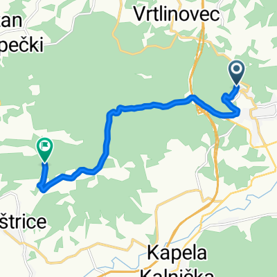
Hike from Varaždinske Toplice to Kalnik via trail number 2
- -:--
- Duration
- 13.6 km
- Distance
- 559 m
- Ascent
- 275 m
- Descent
- ---
- Avg. speed
- ---
- Max. altitude

Continue with Bikemap
Use, edit, or download this cycling route
You would like to ride Vz Toplice Kalnik 2 or customize it for your own trip? Here is what you can do with this Bikemap route:
Free features
- Save this route as favorite or in collections
- Copy & plan your own version of this route
- Sync your route with Garmin or Wahoo
Premium features
Free trial for 3 days, or one-time payment. More about Bikemap Premium.
- Navigate this route on iOS & Android
- Export a GPX / KML file of this route
- Create your custom printout (try it for free)
- Download this route for offline navigation
Discover more Premium features.
Get Bikemap PremiumFrom our community
Other popular routes starting in Ljubešćica
 Vz Toplice Kalnik 3
- Distance
- 13.5 km
- Ascent
- 548 m
- Descent
- 271 m
- Location
- Ljubešćica, Varaždin County, Croatia
 Kalnik 10.5.2020
- Distance
- 15.8 km
- Ascent
- 667 m
- Descent
- 668 m
- Location
- Ljubešćica, Varaždin County, Croatia
 nmarof-kalnik/not finishèd/
- Distance
- 56.6 km
- Ascent
- 712 m
- Descent
- 642 m
- Location
- Ljubešćica, Varaždin County, Croatia
 Kalnik_Picelj
- Distance
- 164.5 km
- Ascent
- 7,141 m
- Descent
- 7,359 m
- Location
- Ljubešćica, Varaždin County, Croatia
 Vratno kruzna
- Distance
- 17 km
- Ascent
- 321 m
- Descent
- 319 m
- Location
- Ljubešćica, Varaždin County, Croatia
 VŽT - Lužec
- Distance
- 7.1 km
- Ascent
- 197 m
- Descent
- 231 m
- Location
- Ljubešćica, Varaždin County, Croatia
 Visoko - Bled
- Distance
- 236.9 km
- Ascent
- 1,040 m
- Descent
- 779 m
- Location
- Ljubešćica, Varaždin County, Croatia
 Slap Šokot
- Distance
- 7.9 km
- Ascent
- 336 m
- Descent
- 339 m
- Location
- Ljubešćica, Varaždin County, Croatia
Open it in the app