

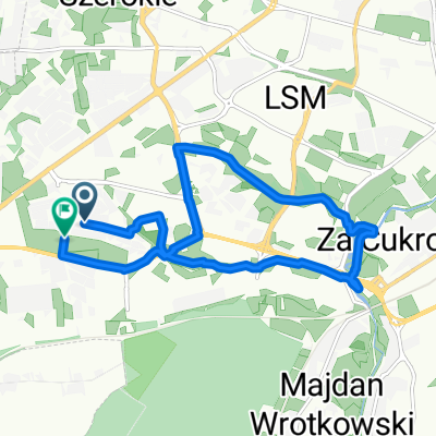
lasy lubelskie
A cycling route starting in Kozubszczyzna, Lublin Voivodeship, Poland.
Overview
About this route
- -:--
- Duration
- 49.4 km
- Distance
- 219 m
- Ascent
- 222 m
- Descent
- ---
- Avg. speed
- ---
- Max. altitude

Route quality
Waytypes & surfaces along the route
Waytypes
Quiet road
17.8 km
(36 %)
Track
13.8 km
(28 %)
Surfaces
Paved
22.7 km
(46 %)
Unpaved
4.4 km
(9 %)
Asphalt
19.8 km
(40 %)
Paved (undefined)
3 km
(6 %)
Continue with Bikemap
Use, edit, or download this cycling route
You would like to ride lasy lubelskie or customize it for your own trip? Here is what you can do with this Bikemap route:
Free features
- Save this route as favorite or in collections
- Copy & plan your own version of this route
- Sync your route with Garmin or Wahoo
Premium features
Free trial for 3 days, or one-time payment. More about Bikemap Premium.
- Navigate this route on iOS & Android
- Export a GPX / KML file of this route
- Create your custom printout (try it for free)
- Download this route for offline navigation
Discover more Premium features.
Get Bikemap PremiumFrom our community
Other popular routes starting in Kozubszczyzna
 Leading Ladies
- Distance
- 39.3 km
- Ascent
- 154 m
- Descent
- 155 m
- Location
- Kozubszczyzna, Lublin Voivodeship, Poland
 lasy lubelskie
- Distance
- 49.4 km
- Ascent
- 219 m
- Descent
- 222 m
- Location
- Kozubszczyzna, Lublin Voivodeship, Poland
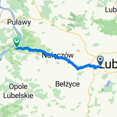 Lublin - Nałęczów - Kazimierz Dolny
- Distance
- 46.4 km
- Ascent
- 263 m
- Descent
- 339 m
- Location
- Kozubszczyzna, Lublin Voivodeship, Poland
 Czarny szlak - Konopnica - Zemborzyce
- Distance
- 28.7 km
- Ascent
- 86 m
- Descent
- 141 m
- Location
- Kozubszczyzna, Lublin Voivodeship, Poland
 Szlak ZIELONY (Lublin - Niedrzwica Kościelna) + Szlak NIEBIESKI (pętelka)
- Distance
- 49.7 km
- Ascent
- 157 m
- Descent
- 158 m
- Location
- Kozubszczyzna, Lublin Voivodeship, Poland
 do radka
- Distance
- 36.1 km
- Ascent
- 226 m
- Descent
- 182 m
- Location
- Kozubszczyzna, Lublin Voivodeship, Poland
 Radawiec do Lublin
- Distance
- 16.8 km
- Ascent
- 75 m
- Descent
- 117 m
- Location
- Kozubszczyzna, Lublin Voivodeship, Poland
 Pętla Wąwozowa
- Distance
- 10.8 km
- Ascent
- 81 m
- Descent
- 83 m
- Location
- Kozubszczyzna, Lublin Voivodeship, Poland
Open it in the app