

salita da Marradi al passo carnevale
A cycling route starting in Marradi, Tuscany, Italy.
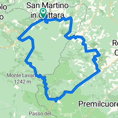
Overview
About this route
An entire stage into the magical florests of the Casentino. From the second day we start to get serious With an altitude increase worthy of a half-mountain stage there will be little time to rest. The first climb of 7-8 km that takes us to Passo Carnevale will be among the sweetest of the whole day. From Marradi, taking to San Benedetto in Alpe the road returns to tighten and creeps into the equally narrow valley of the Rio Salto. From there Eremo and Peschiera with the Casentino forests as background. Arrival at the Acquacheta, now a place and destination of tourism, both for its literary value and for its naturalistic value. From here, a fast succession that runs along the Montone river up to Portico di Romagna to begin the ascent to Valico di Monte Sacco and Busca pass, relatively easy pass, 7.2 km at a 5.0% gradient, then, 6.5 km downhill to Tredozio where you will return to Tuscany passing through the small fraction of Lutirano. This is an insidious part with steep slopes, therefore arriving at Sant Adriano where turning left along the road 302 for 5 km you will arrive at Marradi. We are almost at the end of the day, the first 4 very long kilometers develop at the edge of the narrow valley of the Collecchio ditch, an endless series of curves and counter-curves with a slope that oscillates continuously between 8 and 10%. Now, 6km all downhill to reach Palazzuolo.
- 47 min
- Duration
- 6.6 km
- Distance
- 583 m
- Ascent
- 217 m
- Descent
- 8.4 km/h
- Avg. speed
- 695 m
- Avg. speed

Route quality
Waytypes & surfaces along the route
Waytypes
Busy road
6.6 km
(100 %)
Surfaces
Paved
6.6 km
(100 %)
Asphalt
6.6 km
(100 %)
Continue with Bikemap
Use, edit, or download this cycling route
You would like to ride salita da Marradi al passo carnevale or customize it for your own trip? Here is what you can do with this Bikemap route:
Free features
- Save this route as favorite or in collections
- Copy & plan your own version of this route
- Sync your route with Garmin or Wahoo
Premium features
Free trial for 3 days, or one-time payment. More about Bikemap Premium.
- Navigate this route on iOS & Android
- Export a GPX / KML file of this route
- Create your custom printout (try it for free)
- Download this route for offline navigation
Discover more Premium features.
Get Bikemap PremiumFrom our community
Other popular routes starting in Marradi
 Marradi-Poppi
- Distance
- 97.7 km
- Ascent
- 1,536 m
- Descent
- 1,430 m
- Location
- Marradi, Tuscany, Italy
 salita da Marradi al passo carnevale
- Distance
- 6.6 km
- Ascent
- 583 m
- Descent
- 217 m
- Location
- Marradi, Tuscany, Italy
 S.Adriano-Lutirano-Tredozio-S.Benedetto-Marradi
- Distance
- 66.8 km
- Ascent
- 1,467 m
- Descent
- 1,469 m
- Location
- Marradi, Tuscany, Italy
 S.Andrea-Tredozio-Portico-S.Benedetto in Alpe-Marradi06/ago/2015
- Distance
- 66.9 km
- Ascent
- 1,498 m
- Descent
- 1,501 m
- Location
- Marradi, Tuscany, Italy
 Transparco 1° Tappa
- Distance
- 45.8 km
- Ascent
- 1,622 m
- Descent
- 555 m
- Location
- Marradi, Tuscany, Italy
 Via Fabroni 58, Marradi nach Castello di Valenzano 97, Subbiano
- Distance
- 109.6 km
- Ascent
- 3,084 m
- Descent
- 2,878 m
- Location
- Marradi, Tuscany, Italy
 Crespino del Lamone - Montepiano
- Distance
- 59.5 km
- Ascent
- 1,300 m
- Descent
- 1,144 m
- Location
- Marradi, Tuscany, Italy
 Marradi mortal Trail
- Distance
- 56.8 km
- Ascent
- 2,181 m
- Descent
- 1,990 m
- Location
- Marradi, Tuscany, Italy
Open it in the app