

🚴♀️E*Bike🇦🇹Pramtal R21-Innviertler R22 n.Andorf 06.11.18.
A cycling route starting in Sankt Marienkirchen bei Schärding, Upper Austria, Austria.
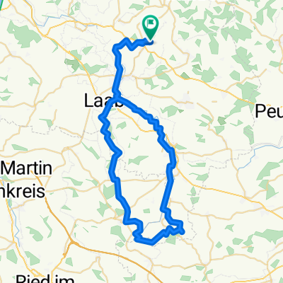
Overview
About this route
- -:--
- Duration
- 50.2 km
- Distance
- 326 m
- Ascent
- 329 m
- Descent
- ---
- Avg. speed
- ---
- Max. altitude

Route quality
Waytypes & surfaces along the route
Waytypes
Quiet road
45.1 km
(90 %)
Cycleway
2.1 km
(4 %)
Surfaces
Paved
3.6 km
(7 %)
Unpaved
3.5 km
(7 %)
Unpaved (undefined)
2.7 km
(5 %)
Asphalt
1.9 km
(4 %)
Route highlights
Points of interest along the route

Photo after 3.6 km

Photo after 7.4 km

Photo after 8.7 km

Photo after 8.7 km

Photo after 9.5 km

Photo after 9.8 km

Photo after 13.7 km

Photo after 13.9 km

Photo after 17.5 km

Photo after 19.6 km

Photo after 21.2 km

Photo after 21.6 km

Photo after 24.9 km

Photo after 24.9 km

Photo after 26.1 km

Photo after 33.5 km

Photo after 34.7 km
Lamprechten

Photo after 37.7 km
Mischanlage Swydelvsky

Photo after 39.8 km

Photo after 41.7 km

Photo after 41.7 km

Photo after 41.8 km

Photo after 48.4 km

Photo after 48.4 km

Photo after 49.2 km

Photo after 49.4 km
Continue with Bikemap
Use, edit, or download this cycling route
You would like to ride 🚴♀️E*Bike🇦🇹Pramtal R21-Innviertler R22 n.Andorf 06.11.18. or customize it for your own trip? Here is what you can do with this Bikemap route:
Free features
- Save this route as favorite or in collections
- Copy & plan your own version of this route
- Sync your route with Garmin or Wahoo
Premium features
Free trial for 3 days, or one-time payment. More about Bikemap Premium.
- Navigate this route on iOS & Android
- Export a GPX / KML file of this route
- Create your custom printout (try it for free)
- Download this route for offline navigation
Discover more Premium features.
Get Bikemap PremiumFrom our community
Other popular routes starting in Sankt Marienkirchen bei Schärding
 Sigh._Andorf_Taiskirchen_Wimmer Stubn_Andorf_Sigh
- Distance
- 54.6 km
- Ascent
- 253 m
- Descent
- 254 m
- Location
- Sankt Marienkirchen bei Schärding, Upper Austria, Austria
 Würding Aigen am Inn
- Distance
- 41.3 km
- Ascent
- 68 m
- Descent
- 68 m
- Location
- Sankt Marienkirchen bei Schärding, Upper Austria, Austria
 Sigh._Schwarzenberg_Langenpeuerb._Steegen_Adenbruck_Zell_Andorf_Sigh.
- Distance
- 44.8 km
- Ascent
- 357 m
- Descent
- 360 m
- Location
- Sankt Marienkirchen bei Schärding, Upper Austria, Austria
 4774 Greiner Mosthof
- Distance
- 14.6 km
- Ascent
- 156 m
- Descent
- 156 m
- Location
- Sankt Marienkirchen bei Schärding, Upper Austria, Austria
 Sigharting-Zell/Pr.-Riedau-Kimpling-Zell/Pr-Linden-Sigharting
- Distance
- 51.2 km
- Ascent
- 244 m
- Descent
- 245 m
- Location
- Sankt Marienkirchen bei Schärding, Upper Austria, Austria
 H 24, 4774 - Schardenberg - H 24
- Distance
- 47.1 km
- Ascent
- 585 m
- Descent
- 565 m
- Location
- Sankt Marienkirchen bei Schärding, Upper Austria, Austria
 ¿øtˇ? nach ¿øtˇ?
- Distance
- 30.2 km
- Ascent
- 509 m
- Descent
- 505 m
- Location
- Sankt Marienkirchen bei Schärding, Upper Austria, Austria
 Route in Eggerding-Au, Sankt Roman
- Distance
- 49.1 km
- Ascent
- 700 m
- Descent
- 663 m
- Location
- Sankt Marienkirchen bei Schärding, Upper Austria, Austria
Open it in the app