

nördlich von Dresden
A cycling route starting in Dresden, Saxony, Germany.
Overview
About this route
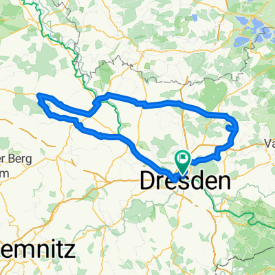
Start / Ziel an den Dresdner Elbwiesen am Hotel Bellevue (beim Goldenen Reiter) - rechtselbisch elbaufwärts bis Körnerplatz - Grundstraße hoch nach Bühlau - Ullersdorf - Großerkmannsdorf - weiter links hinauf nach Kleinwolmsdorf - links nach Wallroda / Kleinröhrsdorf (Abstecher zur Luxoase / ComfortCamping) - links nach Leppersdorf und weiter nach Wachau - rechts nach Lomnitz - westlich weiter nach Ottendorf /Okr.(ev. Pause beim "Mühlenbäcker") - weiter nach Medingen, Großdittmannsdorf bis Radeburg - dort links / südlich nach Berbisdorf, Bärnsdorf, Volkersdorf, Hellerau - zum Moritzburger Weg und ann zurück in die City (über Alaunplatz und Dresdner äußere Neustadt)
- -:--
- Duration
- 72.3 km
- Distance
- 301 m
- Ascent
- 296 m
- Descent
- ---
- Avg. speed
- ---
- Max. altitude

Route quality
Waytypes & surfaces along the route
Waytypes
Road
25.1 km
(35 %)
Busy road
24 km
(33 %)
Surfaces
Paved
65.2 km
(90 %)
Unpaved
0.7 km
(1 %)
Asphalt
62.8 km
(87 %)
Paving stones
1.8 km
(2 %)
Continue with Bikemap
Use, edit, or download this cycling route
You would like to ride nördlich von Dresden or customize it for your own trip? Here is what you can do with this Bikemap route:
Free features
- Save this route as favorite or in collections
- Copy & plan your own version of this route
- Sync your route with Garmin or Wahoo
Premium features
Free trial for 3 days, or one-time payment. More about Bikemap Premium.
- Navigate this route on iOS & Android
- Export a GPX / KML file of this route
- Create your custom printout (try it for free)
- Download this route for offline navigation
Discover more Premium features.
Get Bikemap PremiumFrom our community
Other popular routes starting in Dresden
 Rennradrunde um den Tharandter Wald
- Distance
- 78.9 km
- Ascent
- 934 m
- Descent
- 850 m
- Location
- Dresden, Saxony, Germany
 Dresden - Altenberg
- Distance
- 52.7 km
- Ascent
- 1,016 m
- Descent
- 385 m
- Location
- Dresden, Saxony, Germany
 Pre Velorace Trainingsausfahrt 2015 Einsteiger
- Distance
- 44.6 km
- Ascent
- 222 m
- Descent
- 222 m
- Location
- Dresden, Saxony, Germany
 Müglitztal - Königstein - Breitenau
- Distance
- 156 km
- Ascent
- 2,539 m
- Descent
- 2,398 m
- Location
- Dresden, Saxony, Germany
 Dresden - Stolpen -Rathen
- Distance
- 54 km
- Ascent
- 447 m
- Descent
- 446 m
- Location
- Dresden, Saxony, Germany
 Dresden - Glashütte - Bahratal
- Distance
- 90.4 km
- Ascent
- 1,112 m
- Descent
- 1,142 m
- Location
- Dresden, Saxony, Germany
 DD-Collm-Riesa-Keulenberg-DD
- Distance
- 196.8 km
- Ascent
- 1,000 m
- Descent
- 904 m
- Location
- Dresden, Saxony, Germany
 Schmorsdorfer Höhenrunde
- Distance
- 49.8 km
- Ascent
- 510 m
- Descent
- 488 m
- Location
- Dresden, Saxony, Germany
Open it in the app