

2019 VOGESEN
RG NAGOLDTAL 2019 TAG 1 *4
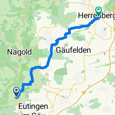
A cycling route starting in Mötzingen, Baden-Wurttemberg, Germany.
Overview
About this route
<p><strong>2019 1.Tag RG Nagoldtal - Vollmaringen Wissembourg </strong></p>
<p>Vollmaringen – Altheim – Salzstetten – Oberwaldach – Vesperweiler – Cresbach – Durrweiler – Kälberbronn – Erzgrube – Besenfeld – Murgtal – Huzenbach – Schönmünzach – Zwickgabel – Sebelseck – B 500 - Neuweier – Steinbach – Weitenung – Sinzheim – Iffezheim – Wintersdorf – Beinheim – Seltz – Schaffhouse-pres-Seltz – Eberbach-Seltz – Trimbach - Seebach – Weißenburg</p>
<p> </p>
Translated, show original (German)- -:--
- Duration
- 140.9 km
- Distance
- 1,169 m
- Ascent
- 1,552 m
- Descent
- ---
- Avg. speed
- ---
- Max. altitude

Part of
2019 VOGESEN
7 stages
Route quality
Waytypes & surfaces along the route
Waytypes
Road
47.9 km
(34 %)
Quiet road
19.7 km
(14 %)
Surfaces
Paved
119.8 km
(85 %)
Unpaved
5.6 km
(4 %)
Asphalt
115.5 km
(82 %)
Paved (undefined)
4.2 km
(3 %)
Continue with Bikemap
Use, edit, or download this cycling route
You would like to ride RG NAGOLDTAL 2019 TAG 1 *4 or customize it for your own trip? Here is what you can do with this Bikemap route:
Free features
- Save this route as favorite or in collections
- Copy & plan your own version of this route
- Split it into stages to create a multi-day tour
- Sync your route with Garmin or Wahoo
Premium features
Free trial for 3 days, or one-time payment. More about Bikemap Premium.
- Navigate this route on iOS & Android
- Export a GPX / KML file of this route
- Create your custom printout (try it for free)
- Download this route for offline navigation
Discover more Premium features.
Get Bikemap PremiumFrom our community
Other popular routes starting in Mötzingen
 PC FamilienRadTour 2011
- Distance
- 25 km
- Ascent
- 301 m
- Descent
- 302 m
- Location
- Mötzingen, Baden-Wurttemberg, Germany
 Sonnige Sonntagstour
- Distance
- 30.7 km
- Ascent
- 522 m
- Descent
- 525 m
- Location
- Mötzingen, Baden-Wurttemberg, Germany
 Warmfahrrunde
- Distance
- 14.3 km
- Ascent
- 139 m
- Descent
- 143 m
- Location
- Mötzingen, Baden-Wurttemberg, Germany
 Gänsäckerweg nach Marktplatz
- Distance
- 20.8 km
- Ascent
- 147 m
- Descent
- 276 m
- Location
- Mötzingen, Baden-Wurttemberg, Germany
 Mötzingen - Baisingen (Variante2)
- Distance
- 4.2 km
- Ascent
- 57 m
- Descent
- 87 m
- Location
- Mötzingen, Baden-Wurttemberg, Germany
 Baisingen-Altnuifra-Haiterbach-Baisingen
- Distance
- 38.2 km
- Ascent
- 856 m
- Descent
- 849 m
- Location
- Mötzingen, Baden-Wurttemberg, Germany
 (planned) Neckar-Tal - Kloster Kirchberg - Neckar- Eyach-Tal
- Distance
- 109.3 km
- Ascent
- 898 m
- Descent
- 899 m
- Location
- Mötzingen, Baden-Wurttemberg, Germany
 Kochhartgraben - Kirchheim Teck
- Distance
- 65.2 km
- Ascent
- 586 m
- Descent
- 879 m
- Location
- Mötzingen, Baden-Wurttemberg, Germany
Open it in the app