

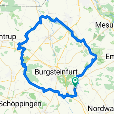
RTF Pumpernickeltour 111 km
A cycling route starting in Steinfurt, North Rhine-Westphalia, Germany.
Overview
About this route
RTF des RSV Friedenau Steinfurt. Letzte Aktualisierung am 26.03.2019
- -:--
- Duration
- 110.1 km
- Distance
- 483 m
- Ascent
- 483 m
- Descent
- ---
- Avg. speed
- ---
- Max. altitude

Route quality
Waytypes & surfaces along the route
Waytypes
Quiet road
34 km
(31 %)
Busy road
32.5 km
(29 %)
Surfaces
Paved
64.8 km
(59 %)
Unpaved
0.2 km
(<1 %)
Asphalt
60.9 km
(55 %)
Paving stones
2.5 km
(2 %)
Route highlights
Points of interest along the route
Point of interest after 26.6 km
K1 Temming 34 48727 Billerbeck
Point of interest after 60.2 km
K2 Draum 60 48301 Nottuln
Point of interest after 84.9 km
K3 Jägerheide 20 48720 Rosendahl
Continue with Bikemap
Use, edit, or download this cycling route
You would like to ride RTF Pumpernickeltour 111 km or customize it for your own trip? Here is what you can do with this Bikemap route:
Free features
- Save this route as favorite or in collections
- Copy & plan your own version of this route
- Split it into stages to create a multi-day tour
- Sync your route with Garmin or Wahoo
Premium features
Free trial for 3 days, or one-time payment. More about Bikemap Premium.
- Navigate this route on iOS & Android
- Export a GPX / KML file of this route
- Create your custom printout (try it for free)
- Download this route for offline navigation
Discover more Premium features.
Get Bikemap PremiumFrom our community
Other popular routes starting in Steinfurt
 Steinfurt, Rheine, Elte Emsdetten Steinfurt
- Distance
- 56.8 km
- Ascent
- 102 m
- Descent
- 108 m
- Location
- Steinfurt, North Rhine-Westphalia, Germany
 Seentour
- Distance
- 54.6 km
- Ascent
- 141 m
- Descent
- 161 m
- Location
- Steinfurt, North Rhine-Westphalia, Germany
 Runde bei Steinfurt
- Distance
- 67.6 km
- Ascent
- 178 m
- Descent
- 178 m
- Location
- Steinfurt, North Rhine-Westphalia, Germany
 2009 11 22 Borghorst - Bagno/B54n/MetelenLand/Dumte
- Distance
- 31.9 km
- Ascent
- 80 m
- Descent
- 80 m
- Location
- Steinfurt, North Rhine-Westphalia, Germany
 Oflumer See
- Distance
- 36.2 km
- Ascent
- 59 m
- Descent
- 62 m
- Location
- Steinfurt, North Rhine-Westphalia, Germany
 Sellen
- Distance
- 19 km
- Ascent
- 56 m
- Descent
- 56 m
- Location
- Steinfurt, North Rhine-Westphalia, Germany
 Auf X Rad- und Wanderwegen rund Steinfurt
- Distance
- 59.2 km
- Ascent
- 102 m
- Descent
- 102 m
- Location
- Steinfurt, North Rhine-Westphalia, Germany
 CS_ST-Metelen-Ochtrup-Lnagenhorst-Wellbergen-ST_29,2km
- Distance
- 39.3 km
- Ascent
- 71 m
- Descent
- 71 m
- Location
- Steinfurt, North Rhine-Westphalia, Germany
Open it in the app