

kleine Bettelmännle-Runde
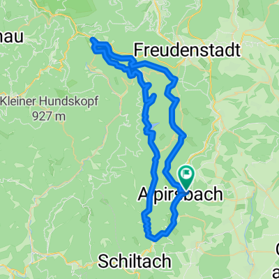
A cycling route starting in Alpirsbach, Baden-Wurttemberg, Germany.
Overview
About this route
Short circuit through the Glaswiesen nature reserve up to Bettelmännle. Here is a beautiful view over Alpirsbach, in good weather even as far as Hohenzollern Castle.
- -:--
- Duration
- 11.9 km
- Distance
- 469 m
- Ascent
- 471 m
- Descent
- ---
- Avg. speed
- ---
- Max. altitude

Route quality
Waytypes & surfaces along the route
Waytypes
Track
9.2 km
(77 %)
Quiet road
1.8 km
(15 %)
Surfaces
Paved
1.5 km
(13 %)
Unpaved
7.9 km
(66 %)
Gravel
7.1 km
(60 %)
Asphalt
1 km
(8 %)
Route highlights
Points of interest along the route

Photo after 2.3 km
Karlsquelle

Photo after 6.6 km
Zollernblick

Photo after 7 km

Photo after 10.6 km
Continue with Bikemap
Use, edit, or download this cycling route
You would like to ride kleine Bettelmännle-Runde or customize it for your own trip? Here is what you can do with this Bikemap route:
Free features
- Save this route as favorite or in collections
- Copy & plan your own version of this route
- Sync your route with Garmin or Wahoo
Premium features
Free trial for 3 days, or one-time payment. More about Bikemap Premium.
- Navigate this route on iOS & Android
- Export a GPX / KML file of this route
- Create your custom printout (try it for free)
- Download this route for offline navigation
Discover more Premium features.
Get Bikemap PremiumFrom our community
Other popular routes starting in Alpirsbach
 MTB_St.Roman
- Distance
- 60.6 km
- Ascent
- 947 m
- Descent
- 951 m
- Location
- Alpirsbach, Baden-Wurttemberg, Germany
 Kinzigtal Schwarzwald
- Distance
- 54.7 km
- Ascent
- 1,015 m
- Descent
- 1,262 m
- Location
- Alpirsbach, Baden-Wurttemberg, Germany
 MTB_Friedrichstal_Stöckerkopf
- Distance
- 59 km
- Ascent
- 1,058 m
- Descent
- 1,056 m
- Location
- Alpirsbach, Baden-Wurttemberg, Germany
 kleine Bettelmännle-Runde
- Distance
- 11.9 km
- Ascent
- 469 m
- Descent
- 471 m
- Location
- Alpirsbach, Baden-Wurttemberg, Germany
 SURM - als KML-Datei
- Distance
- 148.1 km
- Ascent
- 2,007 m
- Descent
- 1,815 m
- Location
- Alpirsbach, Baden-Wurttemberg, Germany
 Alpirsbach zur Kniebishütte über Stausee zurück
- Distance
- 58.9 km
- Ascent
- 697 m
- Descent
- 697 m
- Location
- Alpirsbach, Baden-Wurttemberg, Germany
 Alpi-Loßburg-Wälde-Dornhan-Römlinsdorf-Alpi
- Distance
- 36.3 km
- Ascent
- 687 m
- Descent
- 671 m
- Location
- Alpirsbach, Baden-Wurttemberg, Germany
 Alpirsbach zum Marktplatz Freudenstadt und zurück
- Distance
- 39.7 km
- Ascent
- 622 m
- Descent
- 622 m
- Location
- Alpirsbach, Baden-Wurttemberg, Germany
Open it in the app