

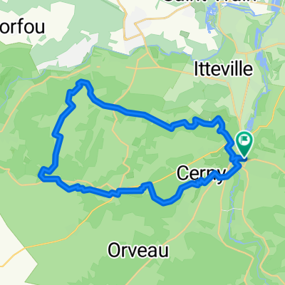
Les Sentiers de Boissy le Cutté
A cycling route starting in La Ferté-Alais, Île-de-France Region, France.
Overview
About this route
- -:--
- Duration
- 31 km
- Distance
- 287 m
- Ascent
- 287 m
- Descent
- ---
- Avg. speed
- ---
- Max. altitude

Route quality
Waytypes & surfaces along the route
Waytypes
Track
18.3 km
(59 %)
Path
7.1 km
(23 %)
Surfaces
Paved
2.5 km
(8 %)
Unpaved
13.9 km
(45 %)
Ground
6.5 km
(21 %)
Unpaved (undefined)
6.2 km
(20 %)
Continue with Bikemap
Use, edit, or download this cycling route
You would like to ride Les Sentiers de Boissy le Cutté or customize it for your own trip? Here is what you can do with this Bikemap route:
Free features
- Save this route as favorite or in collections
- Copy & plan your own version of this route
- Sync your route with Garmin or Wahoo
Premium features
Free trial for 3 days, or one-time payment. More about Bikemap Premium.
- Navigate this route on iOS & Android
- Export a GPX / KML file of this route
- Create your custom printout (try it for free)
- Download this route for offline navigation
Discover more Premium features.
Get Bikemap PremiumFrom our community
Other popular routes starting in La Ferté-Alais
 De Place du Marché, La Ferté-Alais à 14 Rue du Château, D'Huison-Longueville
- Distance
- 3.8 km
- Ascent
- 62 m
- Descent
- 57 m
- Location
- La Ferté-Alais, Île-de-France Region, France
 De 5 Allée Anne de Piedefer, Guigneville-sur-Essonne à 27B Rue des Meuniers, Paris
- Distance
- 54.5 km
- Ascent
- 205 m
- Descent
- 236 m
- Location
- La Ferté-Alais, Île-de-France Region, France
 La Ferté Alais - Boinveau - Villeneuve sur Auvers - Cerny
- Distance
- 34.1 km
- Ascent
- 330 m
- Descent
- 304 m
- Location
- La Ferté-Alais, Île-de-France Region, France
- Avenue Sacha Guitry, Guigneville-sur-Essonne à Rue des Camélias, Ris-Orangis
- Distance
- 30.7 km
- Ascent
- 187 m
- Descent
- 184 m
- Location
- La Ferté-Alais, Île-de-France Region, France
 De Rue Georges Heren 40, La Ferté-Alais à Rue des Freres Mullot 10, La Ferté-Alais
- Distance
- 3.6 km
- Ascent
- 77 m
- Descent
- 73 m
- Location
- La Ferté-Alais, Île-de-France Region, France
 Itinéraire à partir de 9 Rue du Docteur Amodru, La Ferté-Alais
- Distance
- 7.3 km
- Ascent
- 23 m
- Descent
- 14 m
- Location
- La Ferté-Alais, Île-de-France Region, France
 2 Rue du Docteur Amodru, La Ferté-Alais à 62 Boulevard Charles de Gaulle, Mennecy
- Distance
- 12.6 km
- Ascent
- 63 m
- Descent
- 45 m
- Location
- La Ferté-Alais, Île-de-France Region, France
 Les Sentiers de Boissy le Cutté
- Distance
- 31 km
- Ascent
- 287 m
- Descent
- 287 m
- Location
- La Ferté-Alais, Île-de-France Region, France
Open it in the app