

Serra da Estrela
A cycling route starting in Covilha, Castelo Branco District, Portugal.
Overview
About this route
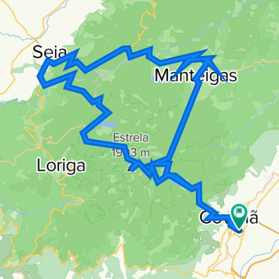
Covilha-Torre-Seia-Penhas Douradas-Manteigas-Penhas da Saúde-Covilha.
- -:--
- Duration
- 111.1 km
- Distance
- 3,040 m
- Ascent
- 3,036 m
- Descent
- ---
- Avg. speed
- ---
- Max. altitude

Route quality
Waytypes & surfaces along the route
Waytypes
Road
13.3 km
(12 %)
Quiet road
5.6 km
(5 %)
Surfaces
Paved
68.9 km
(62 %)
Asphalt
46.7 km
(42 %)
Paved (undefined)
22.2 km
(20 %)
Undefined
42.2 km
(38 %)
Continue with Bikemap
Use, edit, or download this cycling route
You would like to ride Serra da Estrela or customize it for your own trip? Here is what you can do with this Bikemap route:
Free features
- Save this route as favorite or in collections
- Copy & plan your own version of this route
- Split it into stages to create a multi-day tour
- Sync your route with Garmin or Wahoo
Premium features
Free trial for 3 days, or one-time payment. More about Bikemap Premium.
- Navigate this route on iOS & Android
- Export a GPX / KML file of this route
- Create your custom printout (try it for free)
- Download this route for offline navigation
Discover more Premium features.
Get Bikemap PremiumFrom our community
Other popular routes starting in Covilha
 Sierra de La Estrella
- Distance
- 118.3 km
- Ascent
- 3,954 m
- Descent
- 3,956 m
- Location
- Covilha, Castelo Branco District, Portugal
 Serra da Estrela
- Distance
- 111.1 km
- Ascent
- 3,040 m
- Descent
- 3,036 m
- Location
- Covilha, Castelo Branco District, Portugal
 Unhais da Serra - Penhas da Saúde
- Distance
- 31.7 km
- Ascent
- 1,172 m
- Descent
- 1,164 m
- Location
- Covilha, Castelo Branco District, Portugal
 Serra da estrela
- Distance
- 110.4 km
- Ascent
- 3,041 m
- Descent
- 3,043 m
- Location
- Covilha, Castelo Branco District, Portugal
 José María Portillo Zaballos Sierra de La Estrella
- Distance
- 117.1 km
- Ascent
- 3,850 m
- Descent
- 3,852 m
- Location
- Covilha, Castelo Branco District, Portugal
 Covilha - Manteigas
- Distance
- 42.3 km
- Ascent
- 522 m
- Descent
- 427 m
- Location
- Covilha, Castelo Branco District, Portugal
 Sierra de La Estrella
- Distance
- 106.9 km
- Ascent
- 3,426 m
- Descent
- 3,426 m
- Location
- Covilha, Castelo Branco District, Portugal
 Coilha-Salto de Saucelle
- Distance
- 216.9 km
- Ascent
- 3,171 m
- Descent
- 3,435 m
- Location
- Covilha, Castelo Branco District, Portugal
Open it in the app