

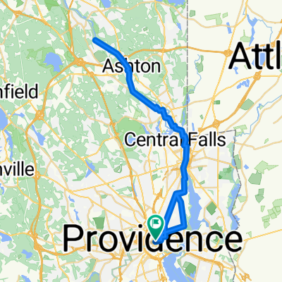
East Bay Path 11/20/18
A cycling route starting in Providence, Rhode Island, United States.
Overview
About this route
- -:--
- Duration
- 20.6 km
- Distance
- 135 m
- Ascent
- 135 m
- Descent
- ---
- Avg. speed
- ---
- Max. altitude
Route quality
Waytypes & surfaces along the route
Waytypes
Cycleway
17.1 km
(83 %)
Quiet road
1.9 km
(9 %)
Surfaces
Paved
19.2 km
(93 %)
Asphalt
18.4 km
(89 %)
Paved (undefined)
0.6 km
(3 %)
Continue with Bikemap
Use, edit, or download this cycling route
You would like to ride East Bay Path 11/20/18 or customize it for your own trip? Here is what you can do with this Bikemap route:
Free features
- Save this route as favorite or in collections
- Copy & plan your own version of this route
- Sync your route with Garmin or Wahoo
Premium features
Free trial for 3 days, or one-time payment. More about Bikemap Premium.
- Navigate this route on iOS & Android
- Export a GPX / KML file of this route
- Create your custom printout (try it for free)
- Download this route for offline navigation
Discover more Premium features.
Get Bikemap PremiumFrom our community
Other popular routes starting in Providence
 Bicycle Tour in Providence
- Distance
- 9.8 km
- Ascent
- 39 m
- Descent
- 36 m
- Location
- Providence, Rhode Island, United States
 Lincoln
- Distance
- 42.3 km
- Ascent
- 166 m
- Descent
- 165 m
- Location
- Providence, Rhode Island, United States
 2010 Eastern Loop
- Distance
- 57.3 km
- Ascent
- 82 m
- Descent
- 82 m
- Location
- Providence, Rhode Island, United States
 East Bay Path 11/20/18
- Distance
- 20.6 km
- Ascent
- 135 m
- Descent
- 135 m
- Location
- Providence, Rhode Island, United States
 Providence
- Distance
- 17.3 km
- Ascent
- 124 m
- Descent
- 124 m
- Location
- Providence, Rhode Island, United States
 Providence Place 171 to South Main Street 123, Attleboro
- Distance
- 77.1 km
- Ascent
- 399 m
- Descent
- 367 m
- Location
- Providence, Rhode Island, United States
 East Bay Bike Path
- Distance
- 29.2 km
- Ascent
- 103 m
- Descent
- 156 m
- Location
- Providence, Rhode Island, United States
 Slow ride in Providence
- Distance
- 42.4 km
- Ascent
- 14 m
- Descent
- 42 m
- Location
- Providence, Rhode Island, United States
Open it in the app