

Westerwaldsteig
A cycling route starting in Freilingen, Rhineland-Palatinate, Germany.
Overview
About this route
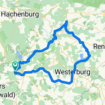
Etappe 6 bis Etappe 16, Freilingen bis Rheinbrohl
- -:--
- Duration
- 161.8 km
- Distance
- 1,415 m
- Ascent
- 1,747 m
- Descent
- ---
- Avg. speed
- ---
- Max. altitude

Route quality
Waytypes & surfaces along the route
Waytypes
Track
91.1 km
(56 %)
Path
39.1 km
(24 %)
Surfaces
Paved
21.1 km
(13 %)
Unpaved
107.8 km
(67 %)
Ground
43.1 km
(27 %)
Gravel
41.4 km
(26 %)
Continue with Bikemap
Use, edit, or download this cycling route
You would like to ride Westerwaldsteig or customize it for your own trip? Here is what you can do with this Bikemap route:
Free features
- Save this route as favorite or in collections
- Copy & plan your own version of this route
- Split it into stages to create a multi-day tour
- Sync your route with Garmin or Wahoo
Premium features
Free trial for 3 days, or one-time payment. More about Bikemap Premium.
- Navigate this route on iOS & Android
- Export a GPX / KML file of this route
- Create your custom printout (try it for free)
- Download this route for offline navigation
Discover more Premium features.
Get Bikemap PremiumFrom our community
Other popular routes starting in Freilingen
 Hohe Straße 11A, Freilingen nach Limburger Straße 44, Holzheim
- Distance
- 38.6 km
- Ascent
- 553 m
- Descent
- 802 m
- Location
- Freilingen, Rhineland-Palatinate, Germany
 Steinen nach Steinen
- Distance
- 50.3 km
- Ascent
- 750 m
- Descent
- 749 m
- Location
- Freilingen, Rhineland-Palatinate, Germany
 Sieben-Weiher-Weg - Schmanddippe - Grüne Schleife (Westerwald)
- Distance
- 10.6 km
- Ascent
- 152 m
- Descent
- 152 m
- Location
- Freilingen, Rhineland-Palatinate, Germany
 7-Weiher-Weg Freilingen / Westerwald
- Distance
- 25.8 km
- Ascent
- 251 m
- Descent
- 252 m
- Location
- Freilingen, Rhineland-Palatinate, Germany
 Westerwaldsteig
- Distance
- 161.8 km
- Ascent
- 1,415 m
- Descent
- 1,747 m
- Location
- Freilingen, Rhineland-Palatinate, Germany
 Radrundweg Seenplatte 2
- Distance
- 28.8 km
- Ascent
- 421 m
- Descent
- 420 m
- Location
- Freilingen, Rhineland-Palatinate, Germany
 7-Weiher-Weg, Freilingen / Westerwald
- Distance
- 25.8 km
- Ascent
- 249 m
- Descent
- 249 m
- Location
- Freilingen, Rhineland-Palatinate, Germany
 Rund um Hachenburg
- Distance
- 54.3 km
- Ascent
- 775 m
- Descent
- 775 m
- Location
- Freilingen, Rhineland-Palatinate, Germany
Open it in the app