

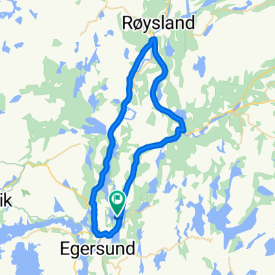
GEObike Egersund- Hellvik- Egersund
A cycling route starting in Egersund, Rogaland, Norway.
Overview
About this route
This route is one of Magma UNESCO Global Geopark's GEObike routes. On this trip you will encounter geological and cultural heritage in a unique landscape - by bike. Biking by the wild coast, through the unique anorthosite landscape shaped by the ice during millions of years, passing an old railwaystation, cultural landscape, a wild salmon river and even viking graves. Pick up a leaflet at our office in Egersund for more information.
- -:--
- Duration
- 24.4 km
- Distance
- 225 m
- Ascent
- 229 m
- Descent
- ---
- Avg. speed
- ---
- Max. altitude

Route photos


Route quality
Waytypes & surfaces along the route
Waytypes
Cycleway
9.8 km
(40 %)
Busy road
7.4 km
(30 %)
Surfaces
Paved
7.4 km
(30 %)
Unpaved
3.8 km
(15 %)
Asphalt
7.4 km
(30 %)
Gravel
3.8 km
(15 %)
Continue with Bikemap
Use, edit, or download this cycling route
You would like to ride GEObike Egersund- Hellvik- Egersund or customize it for your own trip? Here is what you can do with this Bikemap route:
Free features
- Save this route as favorite or in collections
- Copy & plan your own version of this route
- Sync your route with Garmin or Wahoo
Premium features
Free trial for 3 days, or one-time payment. More about Bikemap Premium.
- Navigate this route on iOS & Android
- Export a GPX / KML file of this route
- Create your custom printout (try it for free)
- Download this route for offline navigation
Discover more Premium features.
Get Bikemap PremiumFrom our community
Other popular routes starting in Egersund
 Lagtempo-Dalane SK
- Distance
- 33.4 km
- Ascent
- 245 m
- Descent
- 245 m
- Location
- Egersund, Rogaland, Norway
 Eigerøy runde
- Distance
- 21.9 km
- Ascent
- 180 m
- Descent
- 234 m
- Location
- Egersund, Rogaland, Norway
 stage 4 _ egersund - stavanger
- Distance
- 103 km
- Ascent
- 305 m
- Descent
- 303 m
- Location
- Egersund, Rogaland, Norway
 Johan Feyers gate 4 to Primær Fylkesveg 44 5
- Distance
- 16.1 km
- Ascent
- 206 m
- Descent
- 80 m
- Location
- Egersund, Rogaland, Norway
 Egersund - Bryne
- Distance
- 63.1 km
- Ascent
- 583 m
- Descent
- 570 m
- Location
- Egersund, Rogaland, Norway
 Tour des Fjords Lap #4
- Distance
- 149.1 km
- Ascent
- 904 m
- Descent
- 898 m
- Location
- Egersund, Rogaland, Norway
 Kristiansand-Stavanger - del 4 (Egersund-Stavanger)
- Distance
- 109.5 km
- Ascent
- 601 m
- Descent
- 598 m
- Location
- Egersund, Rogaland, Norway
 GEObike Egersund- Hellvik- Egersund
- Distance
- 24.4 km
- Ascent
- 225 m
- Descent
- 229 m
- Location
- Egersund, Rogaland, Norway
Open it in the app