

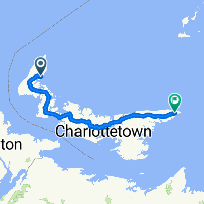
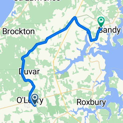
Prince Edward Island
A cycling route starting in Alberton, Prince Edward Island, Canada.
Overview
About this route
- -:--
- Duration
- 589.4 km
- Distance
- 499 m
- Ascent
- 490 m
- Descent
- ---
- Avg. speed
- ---
- Max. altitude

Route quality
Waytypes & surfaces along the route
Waytypes
Cycleway
536.3 km
(91 %)
Road
23.6 km
(4 %)
Surfaces
Paved
41.3 km
(7 %)
Unpaved
200.4 km
(34 %)
Loose gravel
106.1 km
(18 %)
Gravel
70.7 km
(12 %)
Route highlights
Points of interest along the route

Accommodation after 45.6 km
Mill River Resort 180 Mill River Resort Rd. Route 136 PO Box 399 Woodstock, Prince Edward Island Canada C0B 1V0 https://millriver.ca Phone: 902.859.3555

Accommodation after 589.4 km
Prince County Bed and Breakfast 11 Lady Slipper Dr N, Miscouche, PE C0B 1T0, Canada http://www.princecounty.ca/ +1 902-436-3216
Continue with Bikemap
Use, edit, or download this cycling route
You would like to ride Prince Edward Island or customize it for your own trip? Here is what you can do with this Bikemap route:
Free features
- Save this route as favorite or in collections
- Copy & plan your own version of this route
- Split it into stages to create a multi-day tour
- Sync your route with Garmin or Wahoo
Premium features
Free trial for 3 days, or one-time payment. More about Bikemap Premium.
- Navigate this route on iOS & Android
- Export a GPX / KML file of this route
- Create your custom printout (try it for free)
- Download this route for offline navigation
Discover more Premium features.
Get Bikemap PremiumFrom our community
Other popular routes starting in Alberton
 De Albion Street 66, Alberton à Albion Street 66, Alberton
- Distance
- 12.1 km
- Ascent
- 54 m
- Descent
- 33 m
- Location
- Alberton, Prince Edward Island, Canada
 PEI #1
- Distance
- 454.3 km
- Ascent
- 1,905 m
- Descent
- 1,883 m
- Location
- Alberton, Prince Edward Island, Canada
 Bloomfield/Tignish
- Distance
- 79.5 km
- Ascent
- 170 m
- Descent
- 165 m
- Location
- Alberton, Prince Edward Island, Canada
 Trans Canada Trail (PEI): Confederation Trail Main - Alberton to Souris
- Distance
- 251.8 km
- Ascent
- 908 m
- Descent
- 880 m
- Location
- Alberton, Prince Edward Island, Canada
 alberton tidnish retuen
- Distance
- 43.3 km
- Ascent
- 118 m
- Descent
- 117 m
- Location
- Alberton, Prince Edward Island, Canada
 From O'Leary to Alberton
- Distance
- 27.9 km
- Ascent
- 67 m
- Descent
- 83 m
- Location
- Alberton, Prince Edward Island, Canada
 PEI 2019
- Distance
- 269 km
- Ascent
- 389 m
- Descent
- 372 m
- Location
- Alberton, Prince Edward Island, Canada
 alberton cape north retuen
- Distance
- 74.6 km
- Ascent
- 121 m
- Descent
- 120 m
- Location
- Alberton, Prince Edward Island, Canada
Open it in the app