

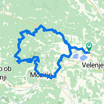
POT 1: Trebeliško - Tuš - Šalek
A cycling route starting in Velenje, Velenje, Slovenia.
Overview
About this route
po kolesarski poti v smeri Šaleškega gradu do semaforja pred tunelom, v križišču zaviješ levo, mimo Osnovne šole Šalek na Selo, mimo obrata plastike, kjer prečkaš glavno cesto Velenje-Slovenj Gradec. Po 200m mimo Vegradovega kamnoloma se priključiš na makadamsko kolesarsko in peš pot ob desnem bregu reke Pake. Prečkaš most (slika A) in se pričneš po asfaltu vzpenjati proti Trebeliškem (nekoč motokros dirke). Od Skaza naprej se prične makadamska cesta vse do kmečkega turizma Tuš. Naprej vodi gozdna steza mimo smerokaza Šentjanška pot do jase z lovsko opazovalnico (slika B), nato nadaljuješ pot delno po markirani poti pod Vernerskim vrhom v Šalek. Skupno 6,53km makadama in gozdne poti.
- -:--
- Duration
- 12.4 km
- Distance
- 341 m
- Ascent
- 340 m
- Descent
- ---
- Avg. speed
- ---
- Max. altitude

Continue with Bikemap
Use, edit, or download this cycling route
You would like to ride POT 1: Trebeliško - Tuš - Šalek or customize it for your own trip? Here is what you can do with this Bikemap route:
Free features
- Save this route as favorite or in collections
- Copy & plan your own version of this route
- Sync your route with Garmin or Wahoo
Premium features
Free trial for 3 days, or one-time payment. More about Bikemap Premium.
- Navigate this route on iOS & Android
- Export a GPX / KML file of this route
- Create your custom printout (try it for free)
- Download this route for offline navigation
Discover more Premium features.
Get Bikemap PremiumFrom our community
Other popular routes starting in Velenje
 Velenje - Sleme - Uršlja gora - Graška gora - Velenje
- Distance
- 77.4 km
- Ascent
- 1,594 m
- Descent
- 1,594 m
- Location
- Velenje, Velenje, Slovenia
 Hrastovec-Gaberke-Vodkriž-Graška Gora-Hrastovec 18.05.2019
- Distance
- 31.9 km
- Ascent
- 788 m
- Descent
- 800 m
- Location
- Velenje, Velenje, Slovenia
 Hrastovec-Sleme-Zg.Zarazbor-Hrastovec 22.04.2019
- Distance
- 50 km
- Ascent
- 1,029 m
- Descent
- 1,032 m
- Location
- Velenje, Velenje, Slovenia
 Hrastovec-Ravne-Velunja-Hrastovec 22.07.2019
- Distance
- 36.7 km
- Ascent
- 427 m
- Descent
- 425 m
- Location
- Velenje, Velenje, Slovenia
 Škale - Sleme - Golte - Škale
- Distance
- 77.6 km
- Ascent
- 1,506 m
- Descent
- 1,499 m
- Location
- Velenje, Velenje, Slovenia
 okoli velenjskega jezera
- Distance
- 9 km
- Ascent
- 173 m
- Descent
- 173 m
- Location
- Velenje, Velenje, Slovenia
 Hrastovec-Ravne-Veluja-Hrastovec 16.04.2019
- Distance
- 29.7 km
- Ascent
- 419 m
- Descent
- 417 m
- Location
- Velenje, Velenje, Slovenia
 Hrastoce-Sleme-Bele vode-Hrastovec 18.06.2019
- Distance
- 48.6 km
- Ascent
- 868 m
- Descent
- 869 m
- Location
- Velenje, Velenje, Slovenia
Open it in the app