MWR 2019 - WĄSKA ELEKTROWNIA WODNA
A cycling route starting in Gronowo Górne, Warmian-Masurian Voivodeship, Poland.
Overview
About this route
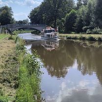
Elektrownia wodna na rzece Wąskiej.
- -:--
- Duration
- 48.7 km
- Distance
- 212 m
- Ascent
- 202 m
- Descent
- ---
- Avg. speed
- ---
- Avg. speed
Route quality
Waytypes & surfaces along the route
Waytypes
Quiet road
20.9 km
(43 %)
Road
10.7 km
(22 %)
Surfaces
Paved
9.2 km
(19 %)
Asphalt
9.2 km
(19 %)
Paving stones
0 km
(<1 %)
Undefined
39.4 km
(81 %)
Continue with Bikemap
Use, edit, or download this cycling route
You would like to ride MWR 2019 - WĄSKA ELEKTROWNIA WODNA or customize it for your own trip? Here is what you can do with this Bikemap route:
Free features
- Save this route as favorite or in collections
- Copy & plan your own version of this route
- Sync your route with Garmin or Wahoo
Premium features
Free trial for 3 days, or one-time payment. More about Bikemap Premium.
- Navigate this route on iOS & Android
- Export a GPX / KML file of this route
- Create your custom printout (try it for free)
- Download this route for offline navigation
Discover more Premium features.
Get Bikemap PremiumFrom our community
Other popular routes starting in Gronowo Górne
- Warmińska 15, Elbląg do Tadeusza Kościuszki 104, Elbląg
- Distance
- 3.8 km
- Ascent
- 28 m
- Descent
- 75 m
- Location
- Gronowo Górne, Warmian-Masurian Voivodeship, Poland
- Wycieczka Nr 18/2024 – Korona Wysoczyzny Elbląskiej – 11 sierpnia
- Distance
- 45.9 km
- Ascent
- 288 m
- Descent
- 232 m
- Location
- Gronowo Górne, Warmian-Masurian Voivodeship, Poland
- MWR 2017 - ZAMROŻONY KANAŁ ELBLĄSKI
- Distance
- 44.9 km
- Ascent
- 69 m
- Descent
- 69 m
- Location
- Gronowo Górne, Warmian-Masurian Voivodeship, Poland
- Wycieczka Nr 05/2020 – Święty Gaj - 05 lipca
- Distance
- 54.5 km
- Ascent
- 122 m
- Descent
- 129 m
- Location
- Gronowo Górne, Warmian-Masurian Voivodeship, Poland
- Pomorska 15, Milejewo do Sadowa 1, Elbląg
- Distance
- 38.4 km
- Ascent
- 276 m
- Descent
- 277 m
- Location
- Gronowo Górne, Warmian-Masurian Voivodeship, Poland
- 19C, Przezmark do Freta 35, Elbląg
- Distance
- 13.9 km
- Ascent
- 27 m
- Descent
- 153 m
- Location
- Gronowo Górne, Warmian-Masurian Voivodeship, Poland
- Wycieczka Nr 15/2018 – Pochylnie Kanału Elbląskiego – 08 lipca
- Distance
- 66.1 km
- Ascent
- 148 m
- Descent
- 153 m
- Location
- Gronowo Górne, Warmian-Masurian Voivodeship, Poland
- Wycieczka Nr 04/2025 – Pasłek – 04 maja Elblag
- Distance
- 43.6 km
- Ascent
- 109 m
- Descent
- 109 m
- Location
- Gronowo Górne, Warmian-Masurian Voivodeship, Poland
Open it in the app