

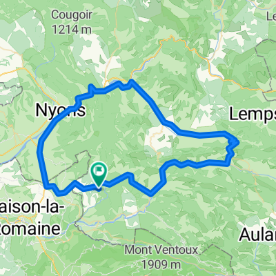
Drome Provençale V2
A cycling route starting in Buis-les-Baronnies, Auvergne-Rhône-Alpes, France.
Overview
About this route
- -:--
- Duration
- 105.2 km
- Distance
- 1,671 m
- Ascent
- 1,670 m
- Descent
- ---
- Avg. speed
- ---
- Max. altitude
Route quality
Waytypes & surfaces along the route
Waytypes
Road
53.6 km
(51 %)
Quiet road
1.1 km
(1 %)
Undefined
50.5 km
(48 %)
Surfaces
Paved
33.7 km
(32 %)
Asphalt
33.7 km
(32 %)
Undefined
71.5 km
(68 %)
Continue with Bikemap
Use, edit, or download this cycling route
You would like to ride Drome Provençale V2 or customize it for your own trip? Here is what you can do with this Bikemap route:
Free features
- Save this route as favorite or in collections
- Copy & plan your own version of this route
- Split it into stages to create a multi-day tour
- Sync your route with Garmin or Wahoo
Premium features
Free trial for 3 days, or one-time payment. More about Bikemap Premium.
- Navigate this route on iOS & Android
- Export a GPX / KML file of this route
- Create your custom printout (try it for free)
- Download this route for offline navigation
Discover more Premium features.
Get Bikemap PremiumFrom our community
Other popular routes starting in Buis-les-Baronnies
 boucle Buis, col de Fontaube, Savoillan
- Distance
- 54.8 km
- Ascent
- 760 m
- Descent
- 760 m
- Location
- Buis-les-Baronnies, Auvergne-Rhône-Alpes, France
 Drôme : Buis - Malaucène - Ventoux - Sault - Aulan - Buis
- Distance
- 112.2 km
- Ascent
- 1,895 m
- Descent
- 1,895 m
- Location
- Buis-les-Baronnies, Auvergne-Rhône-Alpes, France
 CTD-2018-Ventoux 1B
- Distance
- 93.2 km
- Ascent
- 1,916 m
- Descent
- 1,878 m
- Location
- Buis-les-Baronnies, Auvergne-Rhône-Alpes, France
 BlB, CdE, CdS, Nyons, BlB
- Distance
- 92.5 km
- Ascent
- 1,175 m
- Descent
- 1,175 m
- Location
- Buis-les-Baronnies, Auvergne-Rhône-Alpes, France
 F/Propiac-Mirabel-Gouvernet-ret
- Distance
- 75.8 km
- Ascent
- 753 m
- Descent
- 781 m
- Location
- Buis-les-Baronnies, Auvergne-Rhône-Alpes, France
 Drome Provençale V2
- Distance
- 105.2 km
- Ascent
- 1,671 m
- Descent
- 1,670 m
- Location
- Buis-les-Baronnies, Auvergne-Rhône-Alpes, France
 Circuit 2 Buis, Col Perty, col St. Jean, Buis
- Distance
- 90.2 km
- Ascent
- 1,371 m
- Descent
- 1,374 m
- Location
- Buis-les-Baronnies, Auvergne-Rhône-Alpes, France
 Circuit 3 Buis - Gorges de la Nesque - Buis par Malaucène
- Distance
- 122 km
- Ascent
- 1,099 m
- Descent
- 1,097 m
- Location
- Buis-les-Baronnies, Auvergne-Rhône-Alpes, France
Open it in the app