

Rheinhessisches Hügelland bis Hillesheim
A cycling route starting in Worms, Rhineland-Palatinate, Germany.
Overview
About this route
Anfangs leicht, ab Abenheim erste Höhenmeter; zwischen Osthofen und Alsheim flach und gut zu fahren.
Steigung bis kurz vor Dorn-Dürkheim - Pech, mit Gegenwind,
Retour über Dorn-Dürkheim-Raiffeisenstr. Richtung Alsheim durch Hohlweg. Dann flach über Mettenheim, Osthofen nach Worms.
- -:--
- Duration
- 50.6 km
- Distance
- 220 m
- Ascent
- 221 m
- Descent
- ---
- Avg. speed
- ---
- Max. altitude

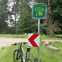
Route photos

Route quality
Waytypes & surfaces along the route
Waytypes
Busy road
16 km
(32 %)
Track
10.8 km
(21 %)
Surfaces
Paved
37.7 km
(74 %)
Unpaved
4.4 km
(9 %)
Asphalt
30.9 km
(61 %)
Concrete
3.7 km
(7 %)
Route highlights
Points of interest along the route
Point of interest after 28.5 km
a
Point of interest after 28.7 km
b
Continue with Bikemap
Use, edit, or download this cycling route
You would like to ride Rheinhessisches Hügelland bis Hillesheim or customize it for your own trip? Here is what you can do with this Bikemap route:
Free features
- Save this route as favorite or in collections
- Copy & plan your own version of this route
- Sync your route with Garmin or Wahoo
Premium features
Free trial for 3 days, or one-time payment. More about Bikemap Premium.
- Navigate this route on iOS & Android
- Export a GPX / KML file of this route
- Create your custom printout (try it for free)
- Download this route for offline navigation
Discover more Premium features.
Get Bikemap PremiumFrom our community
Other popular routes starting in Worms
 Fahrrad Tag Worms bis Oppenheim 5.5.2019
- Distance
- 53.1 km
- Ascent
- 110 m
- Descent
- 110 m
- Location
- Worms, Rhineland-Palatinate, Germany
 Rheinhessisches Hügelland bis Hillesheim
- Distance
- 50.6 km
- Ascent
- 220 m
- Descent
- 221 m
- Location
- Worms, Rhineland-Palatinate, Germany
 Hofheimer Straße, Lampertheim nach Hofheimer Straße, Lampertheim
- Distance
- 42 km
- Ascent
- 51 m
- Descent
- 49 m
- Location
- Worms, Rhineland-Palatinate, Germany
 Lindemannsruh
- Distance
- 88.9 km
- Ascent
- 515 m
- Descent
- 517 m
- Location
- Worms, Rhineland-Palatinate, Germany
 WO-Bürstadt-Karlstern-A6-WO
- Distance
- 46.7 km
- Ascent
- 74 m
- Descent
- 72 m
- Location
- Worms, Rhineland-Palatinate, Germany
 Donnersberg
- Distance
- 81.6 km
- Ascent
- 654 m
- Descent
- 651 m
- Location
- Worms, Rhineland-Palatinate, Germany
 Worms - Kalmit
- Distance
- 64.1 km
- Ascent
- 637 m
- Descent
- 68 m
- Location
- Worms, Rhineland-Palatinate, Germany
 Rheinterrassenroute
- Distance
- 50.3 km
- Ascent
- 64 m
- Descent
- 68 m
- Location
- Worms, Rhineland-Palatinate, Germany
Open it in the app