

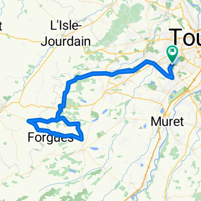
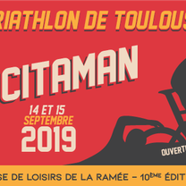
Occitaman 2019 - Parcours Vélo
A cycling route starting in Cugnaux, Occitanie, France.
Overview
About this route
Distance: 174 km
Positive elevation gain: 1700 m
Start from La Ramée, two loops to complete from Sabonnères, then return.
- -:--
- Duration
- 173.8 km
- Distance
- 676 m
- Ascent
- 676 m
- Descent
- ---
- Avg. speed
- ---
- Max. altitude

Route photos

Route quality
Waytypes & surfaces along the route
Waytypes
Road
92.1 km
(53 %)
Quiet road
8.7 km
(5 %)
Surfaces
Paved
33 km
(19 %)
Asphalt
33 km
(19 %)
Undefined
140.8 km
(81 %)
Continue with Bikemap
Use, edit, or download this cycling route
You would like to ride Occitaman 2019 - Parcours Vélo or customize it for your own trip? Here is what you can do with this Bikemap route:
Free features
- Save this route as favorite or in collections
- Copy & plan your own version of this route
- Split it into stages to create a multi-day tour
- Sync your route with Garmin or Wahoo
Premium features
Free trial for 3 days, or one-time payment. More about Bikemap Premium.
- Navigate this route on iOS & Android
- Export a GPX / KML file of this route
- Create your custom printout (try it for free)
- Download this route for offline navigation
Discover more Premium features.
Get Bikemap PremiumFrom our community
Other popular routes starting in Cugnaux
 Half Occ
- Distance
- 97 km
- Ascent
- 407 m
- Descent
- 404 m
- Location
- Cugnaux, Occitanie, France
 TNF-BBG
- Distance
- 154.3 km
- Ascent
- 1,248 m
- Descent
- 856 m
- Location
- Cugnaux, Occitanie, France
 Toulouse ouest
- Distance
- 51.8 km
- Ascent
- 204 m
- Descent
- 203 m
- Location
- Cugnaux, Occitanie, France
 Occitaman 2019 - Parcours Vélo
- Distance
- 173.8 km
- Ascent
- 676 m
- Descent
- 676 m
- Location
- Cugnaux, Occitanie, France
 Route stable en Toulouse
- Distance
- 15.8 km
- Ascent
- 22 m
- Descent
- 42 m
- Location
- Cugnaux, Occitanie, France
 Vélotaf Retour
- Distance
- 5.9 km
- Ascent
- 13 m
- Descent
- 28 m
- Location
- Cugnaux, Occitanie, France
 De Chemin de Larramet 51, Tournefeuille à Boulevard Général de Gaulle 2, Colomiers
- Distance
- 11.8 km
- Ascent
- 550 m
- Descent
- 527 m
- Location
- Cugnaux, Occitanie, France
 Occitaman
- Distance
- 122.5 km
- Ascent
- 495 m
- Descent
- 496 m
- Location
- Cugnaux, Occitanie, France
Open it in the app