

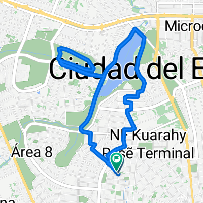
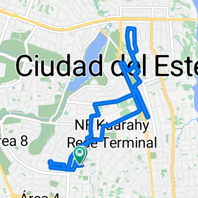
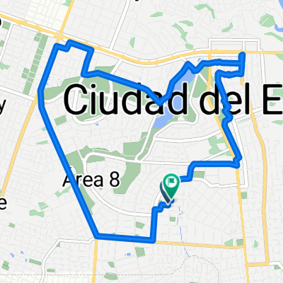
centro de ciudad del este
A cycling route starting in Presidente Franco, Alto Paraná Department, Paraguay.
Overview
About this route
- 25 min
- Duration
- 8 km
- Distance
- 24 m
- Ascent
- 182 m
- Descent
- 18.8 km/h
- Avg. speed
- ---
- Max. altitude

Continue with Bikemap
Use, edit, or download this cycling route
You would like to ride centro de ciudad del este or customize it for your own trip? Here is what you can do with this Bikemap route:
Free features
- Save this route as favorite or in collections
- Copy & plan your own version of this route
- Sync your route with Garmin or Wahoo
Premium features
Free trial for 3 days, or one-time payment. More about Bikemap Premium.
- Navigate this route on iOS & Android
- Export a GPX / KML file of this route
- Create your custom printout (try it for free)
- Download this route for offline navigation
Discover more Premium features.
Get Bikemap PremiumFrom our community
Other popular routes starting in Presidente Franco
 Recovered Route
- Distance
- 25.1 km
- Ascent
- 414 m
- Descent
- 425 m
- Location
- Presidente Franco, Alto Paraná Department, Paraguay
 -25.511° N -54.693° W a Calle 2000,
- Distance
- 34.9 km
- Ascent
- 526 m
- Descent
- 492 m
- Location
- Presidente Franco, Alto Paraná Department, Paraguay
 Paseo rápido en Ciudad del Este
- Distance
- 10 km
- Ascent
- 81 m
- Descent
- 86 m
- Location
- Presidente Franco, Alto Paraná Department, Paraguay
 De F99H+CQG a F99H+CQG
- Distance
- 9.1 km
- Ascent
- 185 m
- Descent
- 192 m
- Location
- Presidente Franco, Alto Paraná Department, Paraguay
 fracción María Graciela
- Distance
- 4.5 km
- Ascent
- 16 m
- Descent
- 29 m
- Location
- Presidente Franco, Alto Paraná Department, Paraguay
 B1 retorno1- Foz do Iguaçu - São Miguel do Iguaçu - Matelândia
- Distance
- 75.3 km
- Ascent
- 807 m
- Descent
- 394 m
- Location
- Presidente Franco, Alto Paraná Department, Paraguay
 De F99H+CQG a F99H+CQG
- Distance
- 9.7 km
- Ascent
- 172 m
- Descent
- 181 m
- Location
- Presidente Franco, Alto Paraná Department, Paraguay
 De F99H+CQG a F99H+CQG
- Distance
- 13.9 km
- Ascent
- 299 m
- Descent
- 311 m
- Location
- Presidente Franco, Alto Paraná Department, Paraguay
Open it in the app