

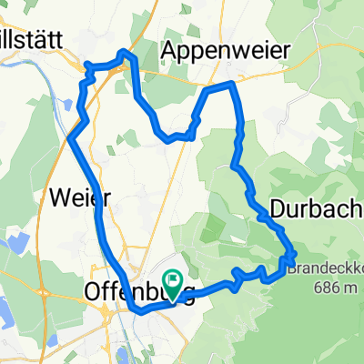
Offenburg-Weier - Wolfsgrube - Brandecklindle -Ohlsbach zurück
A cycling route starting in Offenburg, Baden-Wurttemberg, Germany.
Overview
About this route
- -:--
- Duration
- 32.4 km
- Distance
- 510 m
- Ascent
- 511 m
- Descent
- ---
- Avg. speed
- ---
- Max. altitude

Route quality
Waytypes & surfaces along the route
Waytypes
Track
13.3 km
(41 %)
Quiet road
9.1 km
(28 %)
Surfaces
Paved
21.7 km
(67 %)
Unpaved
8.7 km
(27 %)
Asphalt
15.5 km
(48 %)
Paved (undefined)
6.1 km
(19 %)
Continue with Bikemap
Use, edit, or download this cycling route
You would like to ride Offenburg-Weier - Wolfsgrube - Brandecklindle -Ohlsbach zurück or customize it for your own trip? Here is what you can do with this Bikemap route:
Free features
- Save this route as favorite or in collections
- Copy & plan your own version of this route
- Sync your route with Garmin or Wahoo
Premium features
Free trial for 3 days, or one-time payment. More about Bikemap Premium.
- Navigate this route on iOS & Android
- Export a GPX / KML file of this route
- Create your custom printout (try it for free)
- Download this route for offline navigation
Discover more Premium features.
Get Bikemap PremiumFrom our community
Other popular routes starting in Offenburg
 Ruhestein
- Distance
- 89 km
- Ascent
- 842 m
- Descent
- 842 m
- Location
- Offenburg, Baden-Wurttemberg, Germany
 2009-08-26 0auf2700 Gr1 Flach Rh.bisch.hm
- Distance
- 54.3 km
- Ascent
- 65 m
- Descent
- 68 m
- Location
- Offenburg, Baden-Wurttemberg, Germany
 OG - Nbg über Frankreich
- Distance
- 110.7 km
- Ascent
- 96 m
- Descent
- 28 m
- Location
- Offenburg, Baden-Wurttemberg, Germany
 Horn/F-Eck/Hirschquelle/Horn
- Distance
- 54.2 km
- Ascent
- 1,045 m
- Descent
- 1,045 m
- Location
- Offenburg, Baden-Wurttemberg, Germany
 sand - ebersweier - wolfsgrube
- Distance
- 31.4 km
- Ascent
- 216 m
- Descent
- 217 m
- Location
- Offenburg, Baden-Wurttemberg, Germany
 Gr2_2012_06_19
- Distance
- 47 km
- Ascent
- 29 m
- Descent
- 29 m
- Location
- Offenburg, Baden-Wurttemberg, Germany
 Offenburg-Weier - Wolfsgrube - Brandecklindle -Ohlsbach zurück
- Distance
- 32.4 km
- Ascent
- 510 m
- Descent
- 511 m
- Location
- Offenburg, Baden-Wurttemberg, Germany
 Größere Feierabendrunde
- Distance
- 49.8 km
- Ascent
- 688 m
- Descent
- 686 m
- Location
- Offenburg, Baden-Wurttemberg, Germany
Open it in the app