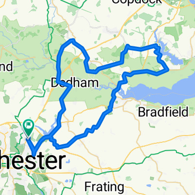
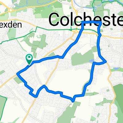
Horkesley, the Tey's & the Layer's Loop
A cycling route starting in Colchester, England, United Kingdom.
Overview
About this route
- -:--
- Duration
- 62.7 km
- Distance
- 181 m
- Ascent
- 184 m
- Descent
- ---
- Avg. speed
- ---
- Max. altitude
Route quality
Waytypes & surfaces along the route
Waytypes
Road
28.2 km
(45 %)
Quiet road
20.7 km
(33 %)
Surfaces
Paved
13.2 km
(21 %)
Unpaved
0.6 km
(1 %)
Asphalt
11.9 km
(19 %)
Paved (undefined)
1.3 km
(2 %)
Continue with Bikemap
Use, edit, or download this cycling route
You would like to ride Horkesley, the Tey's & the Layer's Loop or customize it for your own trip? Here is what you can do with this Bikemap route:
Free features
- Save this route as favorite or in collections
- Copy & plan your own version of this route
- Sync your route with Garmin or Wahoo
Premium features
Free trial for 3 days, or one-time payment. More about Bikemap Premium.
- Navigate this route on iOS & Android
- Export a GPX / KML file of this route
- Create your custom printout (try it for free)
- Download this route for offline navigation
Discover more Premium features.
Get Bikemap PremiumFrom our community
Other popular routes starting in Colchester
Oops - Thought it stopped at Manningtree- Distance
- 19.8 km
- Ascent
- 74 m
- Descent
- 67 m
- Location
- Colchester, England, United Kingdom
50 Mile loop - 03/03/22 - 50 Mile loop - 03/03/22- Distance
- 103 km
- Ascent
- 447 m
- Descent
- 447 m
- Location
- Colchester, England, United Kingdom
Manningtree/Flatford2- Distance
- 54.1 km
- Ascent
- 154 m
- Descent
- 152 m
- Location
- Colchester, England, United Kingdom
Lyndsay and Amanda’s 50k cycle!- Distance
- 56.3 km
- Ascent
- 358 m
- Descent
- 356 m
- Location
- Colchester, England, United Kingdom
Horkesley, the Tey's & the Layer's Loop- Distance
- 62.7 km
- Ascent
- 181 m
- Descent
- 184 m
- Location
- Colchester, England, United Kingdom
easy trip- Distance
- 12.6 km
- Ascent
- 55 m
- Descent
- 56 m
- Location
- Colchester, England, United Kingdom
EA24: Day 2 Colchester - Felixstowe- Distance
- 82.9 km
- Ascent
- 415 m
- Descent
- 424 m
- Location
- Colchester, England, United Kingdom
sunday 14th- Distance
- 67.3 km
- Ascent
- 189 m
- Descent
- 190 m
- Location
- Colchester, England, United Kingdom
Open it in the app

