

11 - ITINERARIO DELLA GRANDE GUERRA / RADTOUR DES 1° WELTKRIEGES / ROUTE OF THE GREAT WAR
A cycling route starting in Gradisca d'Isonzo, Friuli Venezia Giulia, Italy.
Overview
About this route
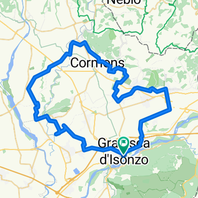
Sfruttando il comodo servizio bici bus è possibile partire da Grado e raggiungere in circa 1 ora Gradisca d’Isonzo da dove iniziare la salita al Monte San Michele, uno dei principali luoghi di battaglia sul Carso durante la Prima Guerra Mondiale. Dopo la visita al nuovo museo interattivo ci si dirige verso Redipuglia passando per Doberdò del Lago e Sagrado. Rientro a Grado con il bici-bus da Redipuglia. Ciascun ciclista pedala sotto la propria esclusiva responsabilità e a proprio rischio e pericolo.
GIORNO/PERIODO CONSIGLIATO: il bici bus Gorizia-Cormons-Grado è attivo da giugno a settembre tutti i sabati, le domeniche e i festivi; partenza da Grado ore 10.10; partenza da Redipuglia il pomeriggio alle ore 17.36. Gli orari dei mezzi di trasporto potrebbero subire variazioni. Verificali sul sito www.tplfvg.it prima di partire.
Durch den praktischen BiciBus ist man von Grado aus in etwa einer Stunde in Gradisca d’Isonzo. Hier kann man mit der Fahrt auf den Monte San Michele, einen der Hauptschlachtplätze im Karst während des ersten Weltkriegs, beginnen. Nach dem Besuch im neuen interaktiven Museum geht es vorbei an Doberdò del Lago und Sagrado weiter Richtung Redipuglia. Rückfahrt nach Grado mit dem BiciBus aus Redipuglia. Jeder Radfahrer radelt auf eigene Verantwortung und auf eigenes Risiko.
EMPFOHLENER TAG/ZEITRAUM: der BiciBus Gorizia-Cormons-Grado verkehrt von Juni bis September samstags, sonntags und feiertags. Abfahrt aus Grado um 10:10 Uhr ; Abfahrt aus Redipuglia am Nachmittag um 17.36 Uhr. Die Fahrpläne können sich ändern. Informieren Sie sich vor Ihrer Abreise auf der Website www.tplfvg.it.
By using the efficient bike-bus service, you can leave from Grado and reach, after half an hour, the town of Gradisca d’Isonzo. From there, you can start the ascent to Monte San Michele, remembered as one the main battlefields on the region of Karst during the First World War. After visiting the new interactive museum, you can reach Redipuglia, crossing the towns of Doberdò del Lago and Sagrado. Return with the bike-bus service from Redipuglia. Each cyclist rides under his or her own responsibility and at his or her own risk.
SUGGESTED DAY/PERIOD OF THE YEAR: the bike-bus service Gorizia-Cormons-Grado is available from June to September on Saturdays, Sundays and during public holidays. Departure from Grado at 10.10 a.m.. Departure from Redipuglia in the afternoon at 5.36 p.m. Transport timetables may be subject to change. Check them on the website www.tplfvg.it before leaving.
- -:--
- Duration
- 23.6 km
- Distance
- 317 m
- Ascent
- 332 m
- Descent
- ---
- Avg. speed
- ---
- Max. altitude

Route photos


Route quality
Waytypes & surfaces along the route
Waytypes
Quiet road
9.9 km
(42 %)
Road
9.1 km
(39 %)
Surfaces
Paved
10.3 km
(44 %)
Unpaved
0.4 km
(2 %)
Asphalt
10 km
(42 %)
Gravel
0.4 km
(2 %)
Route highlights
Points of interest along the route

Point of interest after 6.5 km
Museo interattivo del Monte San Michele
Point of interest after 13.8 km
Riserva Naturale Gradina
Continue with Bikemap
Use, edit, or download this cycling route
You would like to ride 11 - ITINERARIO DELLA GRANDE GUERRA / RADTOUR DES 1° WELTKRIEGES / ROUTE OF THE GREAT WAR or customize it for your own trip? Here is what you can do with this Bikemap route:
Free features
- Save this route as favorite or in collections
- Copy & plan your own version of this route
- Sync your route with Garmin or Wahoo
Premium features
Free trial for 3 days, or one-time payment. More about Bikemap Premium.
- Navigate this route on iOS & Android
- Export a GPX / KML file of this route
- Create your custom printout (try it for free)
- Download this route for offline navigation
Discover more Premium features.
Get Bikemap PremiumFrom our community
Other popular routes starting in Gradisca d'Isonzo
 11 - ITINERARIO DELLA GRANDE GUERRA / RADTOUR DES 1° WELTKRIEGES / ROUTE OF THE GREAT WAR
- Distance
- 23.6 km
- Ascent
- 317 m
- Descent
- 332 m
- Location
- Gradisca d'Isonzo, Friuli Venezia Giulia, Italy
 Tour 2
- Distance
- 46.8 km
- Ascent
- 125 m
- Descent
- 123 m
- Location
- Gradisca d'Isonzo, Friuli Venezia Giulia, Italy
 Hotel Franz - Itinerario 3 - Russiz
- Distance
- 26.7 km
- Ascent
- 99 m
- Descent
- 99 m
- Location
- Gradisca d'Isonzo, Friuli Venezia Giulia, Italy
 Hotel Franz - Itinerario 7 - Gorizia
- Distance
- 41.7 km
- Ascent
- 148 m
- Descent
- 147 m
- Location
- Gradisca d'Isonzo, Friuli Venezia Giulia, Italy
 Gradisca_komen via staniel
- Distance
- 73.8 km
- Ascent
- 565 m
- Descent
- 560 m
- Location
- Gradisca d'Isonzo, Friuli Venezia Giulia, Italy
 Carso 1: Gradisca-S.Martino-S.Michele-Doberdò
- Distance
- 24.6 km
- Ascent
- 332 m
- Descent
- 332 m
- Location
- Gradisca d'Isonzo, Friuli Venezia Giulia, Italy
 Hotel Franz - Itinerario 2 - Ciclabili Versa-Judrio
- Distance
- 39.4 km
- Ascent
- 66 m
- Descent
- 64 m
- Location
- Gradisca d'Isonzo, Friuli Venezia Giulia, Italy
 2009.4-Friaultour, Gradisca-Triest
- Distance
- 45.6 km
- Ascent
- 330 m
- Descent
- 344 m
- Location
- Gradisca d'Isonzo, Friuli Venezia Giulia, Italy
Open it in the app