

Walderalm / Hinterhornalm
A cycling route starting in Gnadenwald, Tyrol, Austria.
Overview
About this route
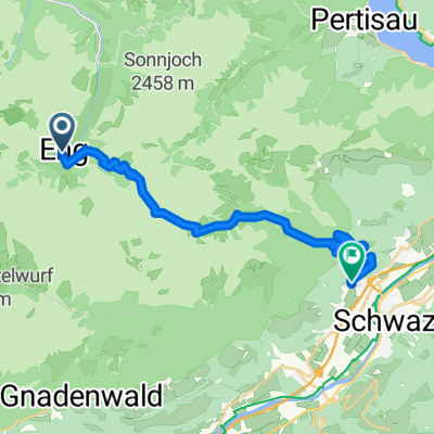
The route begins in Gnadenwald / St. Martin at the parking lot by the Mauthäusel of the Hinterhornalm toll road. From there, it goes on the state road L225 towards the east to St. Michael, further to Brantach, Mairbach to Umlberg. There, the path branches off to the left from the state road. It now leads up a forest road with a constant incline to the Gan Alm (1180 m). From there, the trail continues steep, rocky, and bouldery in places to the highest point, the Walder Alm (1500 m). After that, it goes down to the Hinterhorn Alm and from there back on the asphalt mountain road to the starting point "parking lot".
- -:--
- Duration
- 23.8 km
- Distance
- 713 m
- Ascent
- 715 m
- Descent
- ---
- Avg. speed
- 1,522 m
- Max. altitude

Route photos


Route quality
Waytypes & surfaces along the route
Waytypes
Track
13.3 km
(56 %)
Quiet road
6.7 km
(28 %)
Surfaces
Paved
7.9 km
(33 %)
Unpaved
13.1 km
(55 %)
Gravel
12.1 km
(51 %)
Asphalt
7.9 km
(33 %)
Continue with Bikemap
Use, edit, or download this cycling route
You would like to ride Walderalm / Hinterhornalm or customize it for your own trip? Here is what you can do with this Bikemap route:
Free features
- Save this route as favorite or in collections
- Copy & plan your own version of this route
- Sync your route with Garmin or Wahoo
Premium features
Free trial for 3 days, or one-time payment. More about Bikemap Premium.
- Navigate this route on iOS & Android
- Export a GPX / KML file of this route
- Create your custom printout (try it for free)
- Download this route for offline navigation
Discover more Premium features.
Get Bikemap PremiumFrom our community
Other popular routes starting in Gnadenwald
 Engalm - Lamsensattel - Fiecht
- Distance
- 20 km
- Ascent
- 805 m
- Descent
- 1,419 m
- Location
- Gnadenwald, Tyrol, Austria
 3. Tag: Falken Engalm Plumsjoch Pertisau
- Distance
- 21.8 km
- Ascent
- 866 m
- Descent
- 1,434 m
- Location
- Gnadenwald, Tyrol, Austria
 Naturpark Karwendel-Ulm
- Distance
- 241.9 km
- Ascent
- 568 m
- Descent
- 1,249 m
- Location
- Gnadenwald, Tyrol, Austria
 Gnadenwald Innsbruck und retour
- Distance
- 36.5 km
- Ascent
- 495 m
- Descent
- 495 m
- Location
- Gnadenwald, Tyrol, Austria
 rund wachensee and wally
- Distance
- 136.7 km
- Ascent
- 638 m
- Descent
- 1,216 m
- Location
- Gnadenwald, Tyrol, Austria
 Main - Alpen 9. Teil: Eng-Alm - Grainau
- Distance
- 64.5 km
- Ascent
- 253 m
- Descent
- 710 m
- Location
- Gnadenwald, Tyrol, Austria
 Wallgau-Eng Alm
- Distance
- 37.4 km
- Ascent
- 172 m
- Descent
- 520 m
- Location
- Gnadenwald, Tyrol, Austria
 Von Hinteriss zur Falkenhütte
- Distance
- 33.7 km
- Ascent
- 1,013 m
- Descent
- 1,013 m
- Location
- Gnadenwald, Tyrol, Austria
Open it in the app