

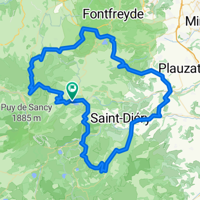
2016 - Auvergne / Col de la Ventouse - Col de Ceyssat - Col de la Moréno
A cycling route starting in Le Mont-Dore, Auvergne-Rhône-Alpes, France.
Overview
About this route
- -:--
- Duration
- 74.1 km
- Distance
- 1,021 m
- Ascent
- 1,019 m
- Descent
- ---
- Avg. speed
- ---
- Max. altitude

Route quality
Waytypes & surfaces along the route
Waytypes
Road
17.1 km
(23 %)
Quiet road
5.2 km
(7 %)
Surfaces
Paved
63 km
(85 %)
Unpaved
1.5 km
(2 %)
Asphalt
63 km
(85 %)
Gravel
0.7 km
(1 %)
Route highlights
Points of interest along the route

Point of interest after 36.2 km
Col de Ceyssat - 1078 m

Point of interest after 46 km
Col de la Moréno - 1062 m

Point of interest after 57.8 km
Col de la Ventouse - 962 m
Continue with Bikemap
Use, edit, or download this cycling route
You would like to ride 2016 - Auvergne / Col de la Ventouse - Col de Ceyssat - Col de la Moréno or customize it for your own trip? Here is what you can do with this Bikemap route:
Free features
- Save this route as favorite or in collections
- Copy & plan your own version of this route
- Sync your route with Garmin or Wahoo
Premium features
Free trial for 3 days, or one-time payment. More about Bikemap Premium.
- Navigate this route on iOS & Android
- Export a GPX / KML file of this route
- Create your custom printout (try it for free)
- Download this route for offline navigation
Discover more Premium features.
Get Bikemap PremiumFrom our community
Other popular routes starting in Le Mont-Dore
 Boucle nord Mont Dore
- Distance
- 64.1 km
- Ascent
- 949 m
- Descent
- 948 m
- Location
- Le Mont-Dore, Auvergne-Rhône-Alpes, France
 Puy de dome 2 - Mont Doré - Sancy
- Distance
- 85 km
- Ascent
- 1,406 m
- Descent
- 1,413 m
- Location
- Le Mont-Dore, Auvergne-Rhône-Alpes, France
 Mont-Dore Trip#2 80km
- Distance
- 80.9 km
- Ascent
- 1,649 m
- Descent
- 1,604 m
- Location
- Le Mont-Dore, Auvergne-Rhône-Alpes, France
 2019-25 Le-Mont-Dore to Riom-ès-Montagnes
- Distance
- 60.4 km
- Ascent
- 716 m
- Descent
- 893 m
- Location
- Le Mont-Dore, Auvergne-Rhône-Alpes, France
 Lac de Guery et retour
- Distance
- 73.1 km
- Ascent
- 1,375 m
- Descent
- 1,377 m
- Location
- Le Mont-Dore, Auvergne-Rhône-Alpes, France
 3.etapa Mont-Dore - Riom-es-Montagnes
- Distance
- 71.2 km
- Ascent
- 1,218 m
- Descent
- 1,380 m
- Location
- Le Mont-Dore, Auvergne-Rhône-Alpes, France
 LAC-2-SERVIERES-TOUR-LAC-2-GUERY
- Distance
- 18.3 km
- Ascent
- 656 m
- Descent
- 656 m
- Location
- Le Mont-Dore, Auvergne-Rhône-Alpes, France
 France 4 - Massif Central 2
- Distance
- 107.7 km
- Ascent
- 1,542 m
- Descent
- 1,542 m
- Location
- Le Mont-Dore, Auvergne-Rhône-Alpes, France
Open it in the app