MINI-RUTA LA EMISORA
- 14.6 km
- 101 m
- 100 m
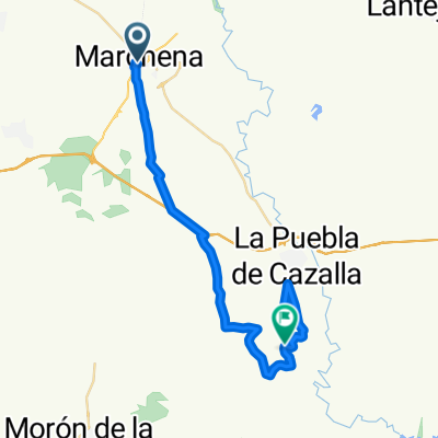
- Marchena, Andalusia, Spain
A cycling route starting in Marchena, Andalusia, Spain.
Overview
It is a fairly easy route to navigate and somewhat leg-breaking.
We start from Marchena heading towards the A-92 highway. If you follow the route exactly, you reach it at the level of the landfill bridge, which we cross and begin a slight uphill. The tendency is to always go straight (following the main path), going up and down a bit until reaching the Moron-Puebla de Cazalla road (SE-7404), which we cross. We continue straight ahead with caution as the path often has water ruts. The path leaves to the right an enclosure where there are usually reddish cows (watch out, we cross a stream). Be careful when going downhill out of an olive grove, as you have to turn right, then about 100 meters later left. We keep climbing until a main path which we take to the left, passing by the farm 'El Morcillo' and continuing about 2 km. Attention: once past a junction (left to La Puebla), we continue straight abandoning the main path and taking an agricultural one, which we continue straight with a slight uphill and then a strong and long downhill (goat farm). At the end of the descent, take care right-left and cross the Corbones river over a very narrow bridge. The path leads us to road SE-8205 (Puebla-Villanieva de San Juan), which we take right for 1.5 km until a bridge (confluence of the Corbones and de la Peña rivers), just before which we take the left on a main path (to the left a natural drinking water source). We continue the path, which after a steep climb deteriorates, but without leaving it we reach the dam. We cross and continue on a road in fair condition, 4 km of moderate but steady uphill. A quick descent of about 5 km to a sign 'EL FONTANAL' where we leave the road to the left onto a rural road, which after about 6 km connects with road SE-8205 (Puebla-Villanieva de San Juan) which we take right for about 4 km until we see on our left a main path indicated towards Moron. We continue on this main path and after a steep 3 km climb (mare farm) we reach a junction (right towards Puebla, which we don't take). We continue straight, pass the farm El Morcillo and take the first path we see to the right. From there, we continue on the same path we had until we reach the landfill bridge. We are already in familiar territory. We cross the bridge and follow the service road of the A-92 highway towards Seville, pass the inn 'Los Cazaores' and continue until reaching the inn 'La Parada'. At this point, we leave the service road and take the agricultural path leaving just before arriving at the inn. Going straight we come to the main path 'camino de las cuestas' and after 7 km we arrive at Marchena.
GOOD ROUTE, COMRADE
created this 17 years ago
Continue with Bikemap
You would like to ride MARCHENA-EL PANTANO or customize it for your own trip? Here is what you can do with this Bikemap route:
Free trial for 3 days, or one-time payment. More about Bikemap Premium.
Discover more Premium features.
Get Bikemap PremiumFrom our community
Open it in the app