

Alpen/Provence 2018 - 7. Tag
A cycling route starting in Carpentras, Provence-Alpes-Côte d'Azur Region, France.
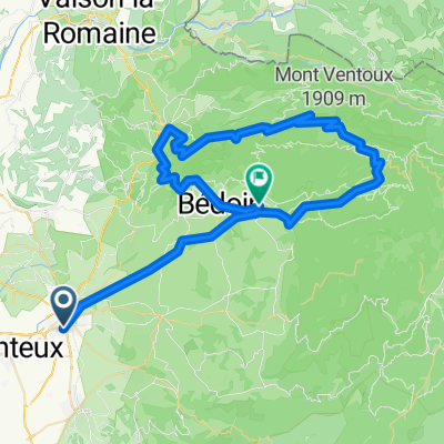
Overview
About this route
The loop from Carpentras through the Gorges de la Nesque to Sault and then back via the eastern slope of Mont Ventoux to Carpentras is one of the most beautiful rides I've done on my road bike.
- -:--
- Duration
- 110.8 km
- Distance
- 1,970 m
- Ascent
- 1,969 m
- Descent
- ---
- Avg. speed
- ---
- Max. altitude

Route photos


Route quality
Waytypes & surfaces along the route
Waytypes
Road
25.5 km
(23 %)
Quiet road
8.9 km
(8 %)
Surfaces
Paved
99.7 km
(90 %)
Asphalt
99.7 km
(90 %)
Undefined
11.1 km
(10 %)
Continue with Bikemap
Use, edit, or download this cycling route
You would like to ride Alpen/Provence 2018 - 7. Tag or customize it for your own trip? Here is what you can do with this Bikemap route:
Free features
- Save this route as favorite or in collections
- Copy & plan your own version of this route
- Split it into stages to create a multi-day tour
- Sync your route with Garmin or Wahoo
Premium features
Free trial for 3 days, or one-time payment. More about Bikemap Premium.
- Navigate this route on iOS & Android
- Export a GPX / KML file of this route
- Create your custom printout (try it for free)
- Download this route for offline navigation
Discover more Premium features.
Get Bikemap PremiumFrom our community
Other popular routes starting in Carpentras
 2. Radetappe Luberon - Camargue
- Distance
- 43.4 km
- Ascent
- 724 m
- Descent
- 512 m
- Location
- Carpentras, Provence-Alpes-Côte d'Azur Region, France
 Alpen/Provence 2018 - 8. Tag
- Distance
- 129.4 km
- Ascent
- 754 m
- Descent
- 772 m
- Location
- Carpentras, Provence-Alpes-Côte d'Azur Region, France
 carpentras-maulacene-mou ventoux-bèdoin-carpentras
- Distance
- 79.4 km
- Ascent
- 1,859 m
- Descent
- 1,877 m
- Location
- Carpentras, Provence-Alpes-Côte d'Azur Region, France
 10. Tag Carpentras - Avignon
- Distance
- 93.5 km
- Ascent
- 718 m
- Descent
- 797 m
- Location
- Carpentras, Provence-Alpes-Côte d'Azur Region, France
 ''Vélocio - Mt Ventoux" - Gorges de la Nesque - 16 Juin 18 - Y.P.
- Distance
- 183 km
- Ascent
- 2,563 m
- Descent
- 2,564 m
- Location
- Carpentras, Provence-Alpes-Côte d'Azur Region, France
 Carpentras - Beames de Venise - Bedoin
- Distance
- 45.6 km
- Ascent
- 337 m
- Descent
- 334 m
- Location
- Carpentras, Provence-Alpes-Côte d'Azur Region, France
 Alpen/Provence 2018 - 7. Tag
- Distance
- 110.8 km
- Ascent
- 1,970 m
- Descent
- 1,969 m
- Location
- Carpentras, Provence-Alpes-Côte d'Azur Region, France
 1. Etappe Carpentras-Ventoux-Bedoin
- Distance
- 71.8 km
- Ascent
- 2,012 m
- Descent
- 1,682 m
- Location
- Carpentras, Provence-Alpes-Côte d'Azur Region, France
Open it in the app