

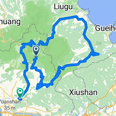
蘆洲站到石牌站
A cycling route starting in Taipei, Taipei, Taiwan.
Overview
About this route
起點:蘆洲站
終點:石牌站
使用上有什麼問題歡迎留言喔
- -:--
- Duration
- 13.3 km
- Distance
- 41 m
- Ascent
- 32 m
- Descent
- ---
- Avg. speed
- ---
- Max. altitude

Route quality
Waytypes & surfaces along the route
Waytypes
Cycleway
8.4 km
(63 %)
Road
3.6 km
(27 %)
Surfaces
Paved
6.3 km
(47 %)
Asphalt
5.5 km
(41 %)
Paved (undefined)
0.5 km
(4 %)
Continue with Bikemap
Use, edit, or download this cycling route
You would like to ride 蘆洲站到石牌站 or customize it for your own trip? Here is what you can do with this Bikemap route:
Free features
- Save this route as favorite or in collections
- Copy & plan your own version of this route
- Sync your route with Garmin or Wahoo
Premium features
Free trial for 3 days, or one-time payment. More about Bikemap Premium.
- Navigate this route on iOS & Android
- Export a GPX / KML file of this route
- Create your custom printout (try it for free)
- Download this route for offline navigation
Discover more Premium features.
Get Bikemap PremiumFrom our community
Other popular routes starting in Taipei
 991024陽金P字道
- Distance
- 80.9 km
- Ascent
- 1,876 m
- Descent
- 1,876 m
- Location
- Taipei, Taipei, Taiwan
 復興南路穿南港南深路轉景美溪回
- Distance
- 44.9 km
- Ascent
- 302 m
- Descent
- 304 m
- Location
- Taipei, Taipei, Taiwan
 榮總-花鐘A路線
- Distance
- 7.3 km
- Ascent
- 522 m
- Descent
- 128 m
- Location
- Taipei, Taipei, Taiwan
 990119劍中劍練跑路線
- Distance
- 18.6 km
- Ascent
- 730 m
- Descent
- 715 m
- Location
- Taipei, Taipei, Taiwan
 P字山道 CLONED FROM ROUTE 447819
- Distance
- 72.3 km
- Ascent
- 1,437 m
- Descent
- 2,140 m
- Location
- Taipei, Taipei, Taiwan
 挑戰:新店_北宜_東北角_北濱_西濱 ... 254公里
- Distance
- 254 km
- Ascent
- 0 m
- Descent
- 0 m
- Location
- Taipei, Taipei, Taiwan
 天母直上大屯山主峰
- Distance
- 36.4 km
- Ascent
- 1,168 m
- Descent
- 1,168 m
- Location
- Taipei, Taipei, Taiwan
 Sep.14,10-環大台北練習
- Distance
- 168.3 km
- Ascent
- 703 m
- Descent
- 703 m
- Location
- Taipei, Taipei, Taiwan
Open it in the app