

04/01/19 (part-2)
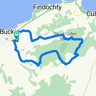
A cycling route starting in Buckie, Scotland, United Kingdom.
Overview
About this route
Portgorden-Garmouth-Lhambryde-Elgin
Total Distance= 40.91 km (25 MIles)
- -:--
- Duration
- 20.1 km
- Distance
- 82 m
- Ascent
- 71 m
- Descent
- ---
- Avg. speed
- ---
- Max. altitude
Route quality
Waytypes & surfaces along the route
Waytypes
Road
13 km
(65 %)
Cycleway
4.7 km
(23 %)
Surfaces
Paved
4 km
(20 %)
Asphalt
3.9 km
(19 %)
Paved (undefined)
0.1 km
(<1 %)
Undefined
16.1 km
(80 %)
Continue with Bikemap
Use, edit, or download this cycling route
You would like to ride 04/01/19 (part-2) or customize it for your own trip? Here is what you can do with this Bikemap route:
Free features
- Save this route as favorite or in collections
- Copy & plan your own version of this route
- Sync your route with Garmin or Wahoo
Premium features
Free trial for 3 days, or one-time payment. More about Bikemap Premium.
- Navigate this route on iOS & Android
- Export a GPX / KML file of this route
- Create your custom printout (try it for free)
- Download this route for offline navigation
Discover more Premium features.
Get Bikemap PremiumFrom our community
Other popular routes starting in Buckie
 04/01/19 (part-2)
- Distance
- 20.1 km
- Ascent
- 82 m
- Descent
- 71 m
- Location
- Buckie, Scotland, United Kingdom
 monster
- Distance
- 21.9 km
- Ascent
- 278 m
- Descent
- 277 m
- Location
- Buckie, Scotland, United Kingdom
 Hop out
- Distance
- 44.5 km
- Ascent
- 183 m
- Descent
- 199 m
- Location
- Buckie, Scotland, United Kingdom
 Monday punisher
- Distance
- 19.4 km
- Ascent
- 283 m
- Descent
- 284 m
- Location
- Buckie, Scotland, United Kingdom
 route 2
- Distance
- 8.8 km
- Ascent
- 63 m
- Descent
- 61 m
- Location
- Buckie, Scotland, United Kingdom
 route 3
- Distance
- 17.2 km
- Ascent
- 213 m
- Descent
- 212 m
- Location
- Buckie, Scotland, United Kingdom
 sunday run....
- Distance
- 18 km
- Ascent
- 218 m
- Descent
- 218 m
- Location
- Buckie, Scotland, United Kingdom
 PEtoLOS
- Distance
- 32.4 km
- Ascent
- 144 m
- Descent
- 161 m
- Location
- Buckie, Scotland, United Kingdom
Open it in the app