
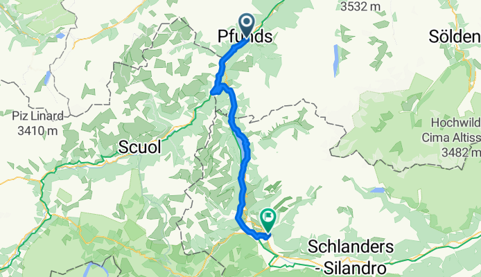
Via 4 - Pfunds - Schlunderns (Reschenpass)
A cycling route starting in Pfunds, Tyrol, Austria.
Overview
About this route
- -:--
- Duration
- 54.3 km
- Distance
- 764 m
- Ascent
- 796 m
- Descent
- ---
- Avg. speed
- ---
- Max. altitude

Route quality
Waytypes & surfaces along the route
Waytypes
Busy road
15 km
(28 %)
Quiet road
14.6 km
(27 %)
Surfaces
Paved
46.5 km
(86 %)
Unpaved
6.2 km
(11 %)
Asphalt
46.3 km
(85 %)
Loose gravel
4 km
(7 %)
Continue with Bikemap
Use, edit, or download this cycling route
You would like to ride Via 4 - Pfunds - Schlunderns (Reschenpass) or customize it for your own trip? Here is what you can do with this Bikemap route:
Free features
- Save this route as favorite or in collections
- Copy & plan your own version of this route
- Sync your route with Garmin or Wahoo
Premium features
Free trial for 3 days, or one-time payment. More about Bikemap Premium.
- Navigate this route on iOS & Android
- Export a GPX / KML file of this route
- Create your custom printout (try it for free)
- Download this route for offline navigation
Discover more Premium features.
Get Bikemap PremiumFrom our community
Other popular routes starting in Pfunds
 Pfingsten_2022-alternate
- Distance
- 237.8 km
- Ascent
- 6,287 m
- Descent
- 6,287 m
- Location
- Pfunds, Tyrol, Austria
 3. Etappe 19.07.2021 Pfunds nach Schluderns
- Distance
- 60.1 km
- Ascent
- 832 m
- Descent
- 878 m
- Location
- Pfunds, Tyrol, Austria
 Svájc 01
- Distance
- 110.8 km
- Ascent
- 1,911 m
- Descent
- 1,913 m
- Location
- Pfunds, Tyrol, Austria
 Dorf, Pfunds a Nauders, Nauders
- Distance
- 24.6 km
- Ascent
- 685 m
- Descent
- 312 m
- Location
- Pfunds, Tyrol, Austria
 Pfingsten_2022
- Distance
- 237.7 km
- Ascent
- 6,621 m
- Descent
- 6,621 m
- Location
- Pfunds, Tyrol, Austria
 CA5b Pfunds to Nauders - shuttle continued (Austria)
- Distance
- 12 km
- Ascent
- 854 m
- Descent
- 435 m
- Location
- Pfunds, Tyrol, Austria
 Pfuns – Taufers
- Distance
- 58.8 km
- Ascent
- 1,731 m
- Descent
- 1,466 m
- Location
- Pfunds, Tyrol, Austria
 Innská-2.den
- Distance
- 115 km
- Ascent
- 146 m
- Descent
- 550 m
- Location
- Pfunds, Tyrol, Austria
Open it in the app