

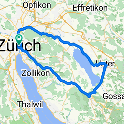
Zürich - Regensburg
A cycling route starting in Zürich (Kreis 1) / Lindenhof, Canton of Zurich, Switzerland.
Overview
About this route
<p>Southern Germany – Tour: Zurich – Regensburg</p>
<p>Stage 0: Zurich – Winterthur</p>
<p>30 km (ascend: 230 m / descend: 200 m)</p>
<p>Stage 1: Winterthur – Andelfingen – Stein am Rhein – Konstanz – (Romanshorn, optional) – Friedrichshafen (ferry)</p>
<p>66 km (optional 85 km / ascend: 370 m / descend: 420 m)</p>
<p>Stage 2: Friedrichshafen – Langenargen – Wasserburg – Lindau – Bregenz</p>
<p>Cable car to Pfänder (with bicycle transport)</p>
<p>Pfänder – Scheidegg – Lindenberg – Röthenbach (rail trail) – Oberstaufen</p>
<p>72 km (ascend: 400 m / descend: 640 m)</p>
<p>Stage 3: Oberstaufen – Immenstadt – Wertach – Füssen</p>
<p>60 km (ascend: 480 m / descend: 480 m)</p>
<p>Spontaneous extension possible via Kempten (+ 20 km / + 70 m)</p>
<p>Stage 4 (main route):</p>
<p>Füssen – Reutte – Plansee – Linderhof Castle – Ettal Monastery – Garmisch-Partenkirchen</p>
<p>73 km (ascend: 580 m / descend: 660 m)</p>
<p>Stage 4 (variant 'Zugspitze' / trip to Zugspitze possible, bus connection from Untergrainau)</p>
<p>Füssen – Reutte – Plansee – Griesen – Untergrainau – Garmisch-Partenkirchen</p>
<p>58 km (ascend: 400 m / descend: 480 m)</p>
<p>Stage 4 (variant 'Wieskirche'):</p>
<p>Füssen – Wieskirche – Oberammergau – Ettal Monastery – Garmisch-Partenkirchen</p>
<p>about 70 km (ascend 470 m / descend 550 m)</p>
<p>Stage 5: Garmisch – Wallgau – Vorderriß – Sylvenstein Reservoir – Lenggries – Bad Tölz</p>
<p>Alternative from Wallgau along Lake Walchensee</p>
<p>64 km (ascend: 380 m / descend: 450 m)</p>
<p>Stage 6: Bad Tölz – Bad Wiessee – Tegernsee – Schliersee – Bayrischzell</p>
<p>Opportunity to ascend Wendelstein (until 5 pm)</p>
<p>54 km (ascend: 450 m / descend: 310 m)</p>
<p>Stage 7: Bayrischzell – Kufstein – Reit im Winkl</p>
<p>59 km (ascend: 470 m / descend: 580 m)</p>
<p>Stage 8: Reit im Winkl – Unterwössen – Seebruck/Chiemsee – Seeon Monastery – Wasserburg am Inn</p>
<p>73 km (ascend: 290 m / descend: 550 m)</p>
<p>Stage 9: Wasserburg am Inn – Erding – Moosburg/Isar – Landshut</p>
<p>89 km (ascend: 220 m / descend: 250 m)</p>
<p>Stage 10: Landshut – Rottenburg/Laaber – Regensburg</p>
<p>79 km (ascend: 230 m / descend: 280 m)</p>
<p>Total distance: 715 km (via Kempten 20 km more / via Zugspitze 17 km less)</p>
<p>Elevation gain: 3610 m up / 4250 m down</p>
<p>The elevation difference results from the height difference between Zurich and Regensburg, mainly due to the use of the cable car to the Pfänder summit. This also overcomes the steep climb at the beginning of the elevation profile.</p>
Translated, show original (German)- -:--
- Duration
- 778.7 km
- Distance
- 2,173 m
- Ascent
- 2,230 m
- Descent
- ---
- Avg. speed
- ---
- Max. altitude

Continue with Bikemap
Use, edit, or download this cycling route
You would like to ride Zürich - Regensburg or customize it for your own trip? Here is what you can do with this Bikemap route:
Free features
- Save this route as favorite or in collections
- Copy & plan your own version of this route
- Split it into stages to create a multi-day tour
- Sync your route with Garmin or Wahoo
Premium features
Free trial for 3 days, or one-time payment. More about Bikemap Premium.
- Navigate this route on iOS & Android
- Export a GPX / KML file of this route
- Create your custom printout (try it for free)
- Download this route for offline navigation
Discover more Premium features.
Get Bikemap PremiumFrom our community
Other popular routes starting in Zürich (Kreis 1) / Lindenhof
 Cyklotrip 2011 - den 1
- Distance
- 130 km
- Ascent
- 650 m
- Descent
- 586 m
- Location
- Zürich (Kreis 1) / Lindenhof, Canton of Zurich, Switzerland
 penzello
- Distance
- 100.9 km
- Ascent
- 1,458 m
- Descent
- 1,076 m
- Location
- Zürich (Kreis 1) / Lindenhof, Canton of Zurich, Switzerland
 Uster - Greifensee
- Distance
- 42.6 km
- Ascent
- 370 m
- Descent
- 370 m
- Location
- Zürich (Kreis 1) / Lindenhof, Canton of Zurich, Switzerland
 Zürich - Rapperswil
- Distance
- 44.2 km
- Ascent
- 34 m
- Descent
- 32 m
- Location
- Zürich (Kreis 1) / Lindenhof, Canton of Zurich, Switzerland
 Zürich-Vaduz-Chur-St.Moritz-Chiavenna-Como-Milan-Bergamo
- Distance
- 488.4 km
- Ascent
- 2,852 m
- Descent
- 3,012 m
- Location
- Zürich (Kreis 1) / Lindenhof, Canton of Zurich, Switzerland
 Drei Voralpenpässe, Albispass, Ratenpass, Sattelegg
- Distance
- 129.6 km
- Ascent
- 1,792 m
- Descent
- 1,784 m
- Location
- Zürich (Kreis 1) / Lindenhof, Canton of Zurich, Switzerland
 E12. 20.7.25 Zürich HB nach Hause
- Distance
- 15.6 km
- Ascent
- 180 m
- Descent
- 204 m
- Location
- Zürich (Kreis 1) / Lindenhof, Canton of Zurich, Switzerland
 Zurich to Stein am Rhein
- Distance
- 58.9 km
- Ascent
- 732 m
- Descent
- 740 m
- Location
- Zürich (Kreis 1) / Lindenhof, Canton of Zurich, Switzerland
Open it in the app