

Overview
About this route
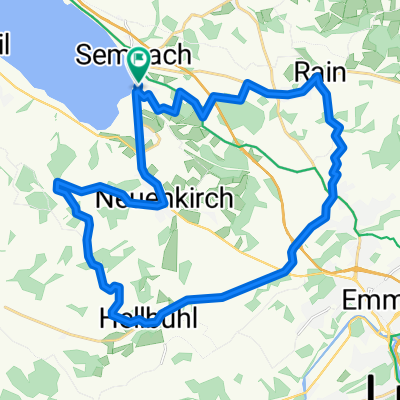
Biometzger (Hof Maiengrün, Igelweid 8)
- -:--
- Duration
- 35 km
- Distance
- 364 m
- Ascent
- 404 m
- Descent
- ---
- Avg. speed
- ---
- Max. altitude

Part of
ab Sempach
1 stage
Route quality
Waytypes & surfaces along the route
Waytypes
Road
9.8 km
(28 %)
Quiet road
6.3 km
(18 %)
Surfaces
Paved
15.8 km
(45 %)
Unpaved
3.2 km
(9 %)
Asphalt
15.8 km
(45 %)
Gravel
3.2 km
(9 %)
Undefined
16.1 km
(46 %)
Continue with Bikemap
Use, edit, or download this cycling route
You would like to ride Sempach-Hägglingen or customize it for your own trip? Here is what you can do with this Bikemap route:
Free features
- Save this route as favorite or in collections
- Copy & plan your own version of this route
- Sync your route with Garmin or Wahoo
Premium features
Free trial for 3 days, or one-time payment. More about Bikemap Premium.
- Navigate this route on iOS & Android
- Export a GPX / KML file of this route
- Create your custom printout (try it for free)
- Download this route for offline navigation
Discover more Premium features.
Get Bikemap PremiumFrom our community
Other popular routes starting in Sempach
 Sempach - Beromünster
- Distance
- 29.1 km
- Ascent
- 443 m
- Descent
- 442 m
- Location
- Sempach, Canton of Lucerne, Switzerland
 Coupierte Seonroute
- Distance
- 70.1 km
- Ascent
- 914 m
- Descent
- 766 m
- Location
- Sempach, Canton of Lucerne, Switzerland
 Schulreise
- Distance
- 27.2 km
- Ascent
- 348 m
- Descent
- 364 m
- Location
- Sempach, Canton of Lucerne, Switzerland
 TTCH_08
- Distance
- 90.2 km
- Ascent
- 881 m
- Descent
- 1,048 m
- Location
- Sempach, Canton of Lucerne, Switzerland
 BikeComputer Aufnahme
- Distance
- 19.4 km
- Ascent
- 55 m
- Descent
- 53 m
- Location
- Sempach, Canton of Lucerne, Switzerland
 04.06.2015 12:58
- Distance
- 31.2 km
- Ascent
- 368 m
- Descent
- 361 m
- Location
- Sempach, Canton of Lucerne, Switzerland
 sursee - walkringen
- Distance
- 72 km
- Ascent
- 756 m
- Descent
- 558 m
- Location
- Sempach, Canton of Lucerne, Switzerland
 Rathausen
- Distance
- 10.9 km
- Ascent
- 49 m
- Descent
- 180 m
- Location
- Sempach, Canton of Lucerne, Switzerland
Open it in the app