

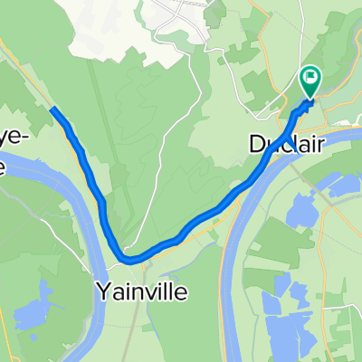
Duclair Ste Marg'
A cycling route starting in Duclair, Normandy, France.
Overview
About this route
Return of the ferry
- -:--
- Duration
- 15.5 km
- Distance
- 156 m
- Ascent
- 47 m
- Descent
- ---
- Avg. speed
- ---
- Max. altitude

Route quality
Waytypes & surfaces along the route
Waytypes
Road
7.8 km
(50 %)
Quiet road
2.2 km
(14 %)
Surfaces
Paved
12 km
(77 %)
Asphalt
12 km
(77 %)
Undefined
3.6 km
(23 %)
Continue with Bikemap
Use, edit, or download this cycling route
You would like to ride Duclair Ste Marg' or customize it for your own trip? Here is what you can do with this Bikemap route:
Free features
- Save this route as favorite or in collections
- Copy & plan your own version of this route
- Sync your route with Garmin or Wahoo
Premium features
Free trial for 3 days, or one-time payment. More about Bikemap Premium.
- Navigate this route on iOS & Android
- Export a GPX / KML file of this route
- Create your custom printout (try it for free)
- Download this route for offline navigation
Discover more Premium features.
Get Bikemap PremiumFrom our community
Other popular routes starting in Duclair
 De 880–1178 Rue du Village, Berville-sur-Seine à Rue du Quesney, Jumièges
- Distance
- 19.1 km
- Ascent
- 0 m
- Descent
- 6 m
- Location
- Duclair, Normandy, France
 duclair le trait.
- Distance
- 20.4 km
- Ascent
- 163 m
- Descent
- 161 m
- Location
- Duclair, Normandy, France
 Itinéraire à partir de Rue Antonio Vivaldi 152, Duclair
- Distance
- 26 km
- Ascent
- 218 m
- Descent
- 260 m
- Location
- Duclair, Normandy, France
 Itinéraire à partir de Rue Antonio Vivaldi 44, Duclair
- Distance
- 20 km
- Ascent
- 83 m
- Descent
- 157 m
- Location
- Duclair, Normandy, France
 De Quai de la Libération 340, Duclair à Route du Manoir 1635, Le Mesnil-sous-Jumièges
- Distance
- 8.3 km
- Ascent
- 43 m
- Descent
- 34 m
- Location
- Duclair, Normandy, France
 Itinéraire à partir de Rue Antonio Vivaldi 152, Duclair
- Distance
- 19.4 km
- Ascent
- 87 m
- Descent
- 83 m
- Location
- Duclair, Normandy, France
 Berville-Rouen via La Bouille
- Distance
- 43.2 km
- Ascent
- 219 m
- Descent
- 208 m
- Location
- Duclair, Normandy, France
 Sur les courbes et les collines de la Seine de Duclair
- Distance
- 42.3 km
- Ascent
- 364 m
- Descent
- 367 m
- Location
- Duclair, Normandy, France
Open it in the app