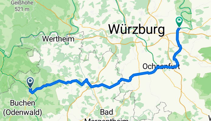
Tag 3 2019 Walldürn/Dettelbach
A cycling route starting in Walldürn, Baden-Württemberg, Germany.
Overview
About this route
- -:--
- Duration
- 91.2 km
- Distance
- 374 m
- Ascent
- 594 m
- Descent
- ---
- Avg. speed
- ---
- Avg. speed
Route quality
Waytypes & surfaces along the route
Waytypes
Track
22.4 km
(25 %)
Road
17.3 km
(19 %)
Surfaces
Paved
75.5 km
(83 %)
Asphalt
68.3 km
(75 %)
Paved (undefined)
6.8 km
(7 %)
Route highlights
Points of interest along the route
Point of interest after 30.7 km
Papamobil
Point of interest after 68.7 km
Mittagspause
Continue with Bikemap
Use, edit, or download this cycling route
You would like to ride Tag 3 2019 Walldürn/Dettelbach or customize it for your own trip? Here is what you can do with this Bikemap route:
Free features
- Save this route as favorite or in collections
- Copy & plan your own version of this route
- Sync your route with Garmin or Wahoo
Premium features
Free trial for 3 days, or one-time payment. More about Bikemap Premium.
- Navigate this route on iOS & Android
- Export a GPX / KML file of this route
- Create your custom printout (try it for free)
- Download this route for offline navigation
Discover more Premium features.
Get Bikemap PremiumFrom our community
Other popular routes starting in Walldürn
- Südlicher Jakobsweg
- Distance
- 2,573.4 km
- Ascent
- 3,063 m
- Descent
- 3,171 m
- Location
- Walldürn, Baden-Württemberg, Germany
- Baden - Bauland - Bayern
- Distance
- 106.1 km
- Ascent
- 1,075 m
- Descent
- 1,118 m
- Location
- Walldürn, Baden-Württemberg, Germany
- Vom Odenwald nach Santiago
- Distance
- 2,517.5 km
- Ascent
- 4,150 m
- Descent
- 4,331 m
- Location
- Walldürn, Baden-Württemberg, Germany
- Grünkernradweg ab Walldürn
- Distance
- 78.5 km
- Ascent
- 759 m
- Descent
- 758 m
- Location
- Walldürn, Baden-Württemberg, Germany
- Walldürn-Buchen-Schneeberg-Walldürn
- Distance
- 37 km
- Ascent
- 700 m
- Descent
- 706 m
- Location
- Walldürn, Baden-Württemberg, Germany
- Walldürn - Rothenburg ob der Tauber
- Distance
- 157.7 km
- Ascent
- 441 m
- Descent
- 438 m
- Location
- Walldürn, Baden-Württemberg, Germany
- Walldürn - Hardheim - Külsheim - Kloster Bronnbach - Uissigheim - Hundheim - Reinhardsachsen - Walldürn
- Distance
- 70.7 km
- Ascent
- 1,142 m
- Descent
- 1,144 m
- Location
- Walldürn, Baden-Württemberg, Germany
- walldürn - kloster schöntal
- Distance
- 36 km
- Ascent
- 338 m
- Descent
- 517 m
- Location
- Walldürn, Baden-Württemberg, Germany
Open it in the app