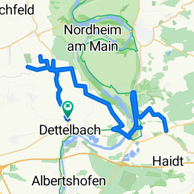
Tag 4 Dettelbach/Bad Bocklet
A cycling route starting in Dettelbach, Bavaria, Germany.
Overview
About this route
- -:--
- Duration
- 73.8 km
- Distance
- 301 m
- Ascent
- 260 m
- Descent
- ---
- Avg. speed
- ---
- Avg. speed
Route quality
Waytypes & surfaces along the route
Waytypes
Path
21.4 km
(29 %)
Quiet road
19.6 km
(27 %)
Surfaces
Paved
53 km
(72 %)
Unpaved
10.5 km
(14 %)
Asphalt
51.9 km
(70 %)
Loose gravel
4.2 km
(6 %)
Route highlights
Points of interest along the route
Point of interest after 35.2 km
Papamobilpause
Continue with Bikemap
Use, edit, or download this cycling route
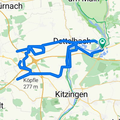
You would like to ride Tag 4 Dettelbach/Bad Bocklet or customize it for your own trip? Here is what you can do with this Bikemap route:
Free features
- Save this route as favorite or in collections
- Copy & plan your own version of this route
- Sync your route with Garmin or Wahoo
Premium features
Free trial for 3 days, or one-time payment. More about Bikemap Premium.
- Navigate this route on iOS & Android
- Export a GPX / KML file of this route
- Create your custom printout (try it for free)
- Download this route for offline navigation
Discover more Premium features.
Get Bikemap PremiumFrom our community
Other popular routes starting in Dettelbach
- 17-4DETTELBACH-GEMÜNDEN
- Distance
- 87.5 km
- Ascent
- 83 m
- Descent
- 119 m
- Location
- Dettelbach, Bavaria, Germany
- Tag 4 Dettelbach/Bad Bocklet
- Distance
- 73.8 km
- Ascent
- 301 m
- Descent
- 260 m
- Location
- Dettelbach, Bavaria, Germany
- Mainschleife: Mainsondheim-Volkach retour
- Distance
- 33.3 km
- Ascent
- 210 m
- Descent
- 210 m
- Location
- Dettelbach, Bavaria, Germany
- Etappe_06_bike
- Distance
- 46.2 km
- Ascent
- 70 m
- Descent
- 106 m
- Location
- Dettelbach, Bavaria, Germany
- Kripo Radtour 2014 - 2. Tag
- Distance
- 47 km
- Ascent
- 352 m
- Descent
- 258 m
- Location
- Dettelbach, Bavaria, Germany
- Genießer-Tour (Tour 2) - Genießer-Tour (Tour 2)
- Distance
- 41 km
- Ascent
- 228 m
- Descent
- 226 m
- Location
- Dettelbach, Bavaria, Germany
- B22, Schwarzach am Main nach Schweinfurter Straße 97, Schwarzach am Main
- Distance
- 25.8 km
- Ascent
- 100 m
- Descent
- 96 m
- Location
- Dettelbach, Bavaria, Germany
- Dettelbach längs dem Main nach Würzburg und zurück durchs Land
- Distance
- 64.8 km
- Ascent
- 399 m
- Descent
- 300 m
- Location
- Dettelbach, Bavaria, Germany
Open it in the app