
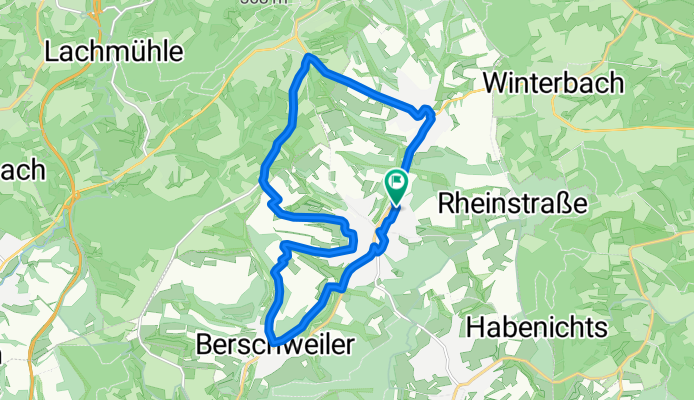
Rundweg Marpinger Land
A cycling route starting in Marpingen, Saarland, Germany.
Overview
About this route
Short tour in the Marpingen Nature Reserve (Beaver Bridge / Beaver Path) – towards Berschweiler – passing Waschburger Hof towards the airfield, over Geierschell and Auf der Sang, passing the church – passing the castle tavern, uphill towards Tholeyer Chaussee – cross-country over the field to the Chaussee – towards Alsweiler, back to Marpingen
- -:--
- Duration
- 16.7 km
- Distance
- 251 m
- Ascent
- 251 m
- Descent
- ---
- Avg. speed
- ---
- Max. altitude
Continue with Bikemap
Use, edit, or download this cycling route
You would like to ride Rundweg Marpinger Land or customize it for your own trip? Here is what you can do with this Bikemap route:
Free features
- Save this route as favorite or in collections
- Copy & plan your own version of this route
- Sync your route with Garmin or Wahoo
Premium features
Free trial for 3 days, or one-time payment. More about Bikemap Premium.
- Navigate this route on iOS & Android
- Export a GPX / KML file of this route
- Create your custom printout (try it for free)
- Download this route for offline navigation
Discover more Premium features.
Get Bikemap PremiumFrom our community
Other popular routes starting in Marpingen
 Friedrichstraße nach Am Langenstrank
- Distance
- 40.6 km
- Ascent
- 510 m
- Descent
- 557 m
- Location
- Marpingen, Saarland, Germany
 MTB 5 Sankt Wendeler Land
- Distance
- 21.1 km
- Ascent
- 339 m
- Descent
- 339 m
- Location
- Marpingen, Saarland, Germany
 Sankt Wendeler Land 1
- Distance
- 48.6 km
- Ascent
- 475 m
- Descent
- 497 m
- Location
- Marpingen, Saarland, Germany
 Wünschberg Tour
- Distance
- 41.7 km
- Ascent
- 533 m
- Descent
- 533 m
- Location
- Marpingen, Saarland, Germany
 Marpingen - Skulpturenstraße - Bostalsee
- Distance
- 54.7 km
- Ascent
- 602 m
- Descent
- 617 m
- Location
- Marpingen, Saarland, Germany
 Marpingen Rheinstrasse Warm-Up
- Distance
- 11.9 km
- Ascent
- 262 m
- Descent
- 204 m
- Location
- Marpingen, Saarland, Germany
 Am Langenstrank nach Am Langenstrank
- Distance
- 38.9 km
- Ascent
- 560 m
- Descent
- 604 m
- Location
- Marpingen, Saarland, Germany
 Rundweg Marpinger Land
- Distance
- 16.7 km
- Ascent
- 251 m
- Descent
- 251 m
- Location
- Marpingen, Saarland, Germany
Open it in the app