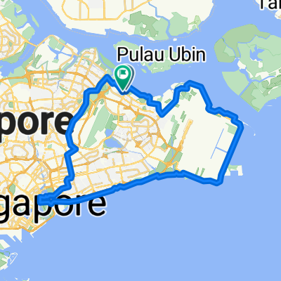
Punggol East, Singapore to Kallang, Singapore
- 49.6 km
- 125 m
- 130 m
- Singapore, Central Singapore Community Development Council, Singapore
A cycling route starting in Singapore, Central Singapore Community Development Council, Singapore.
Overview
Meeting Point: Legend @ Anchorvale Community Club
Moving out time: 0730 hrs sharp
End time : 1230 hrs
Breakfast Point : Maxwell Market
Route : (subject to changes when necessary)
AVCC - Fernvale St - Fernvale Rd - Sengkang West Way - Sengkang West Rd - KnightsbridgeRd - Seletar Aerospace Dr - West Camp Rd - Yishun Ave 1 - Sembawang Rd - Upper Thomson Rd - Marymount Lane - Marymount Rd - Thomson Rd - Kampong Java Rd - Bukit Timah Rd - Sungei Rd - Ophir Rd - North Bridge Rd - South Bridge Rd - Erskine Rd - Maxwell Market (breakfast stop)
Maxwell Rd - Cecil St - Collyer Quay - Esplanade Dr - Nicoll Highway - Stadium Dr - Stadium Walk - Stadium Cres - Stadium Way - Tanjong Rhu Bridge - Tanjong Rhu Rd - ECP Service Rd (1st re-group @ ECP B1 carpark)
East Coast Service Rd - East Coast PCN (2nd regroup @NSRCC)
Tanah Merah Coast Rd - Nicoll Dr - Telok Paku Rd - Netheravon Rd - Cranwell Rd - Loyang Ave (4th regroup @ Shell station)
Pasir Ris Dr 3 - Pasir Ris Dr 12 - Pasir Ris Ind Dr 1 - Pasir Ris Farmway - EC Club Cafe @ Oasis Terrace
created this 6 years ago
Continue with Bikemap
You would like to ride MBG - Sat 19 Jan 2019 1/2 Island Ride or customize it for your own trip? Here is what you can do with this Bikemap route:
Free trial for 3 days, or one-time payment. More about Bikemap Premium.
Discover more Premium features.
Get Bikemap PremiumFrom our community
Open it in the app